Guliston
City in eastern Uzbekistan From Wikipedia, the free encyclopedia
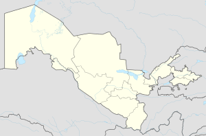
Guliston (Uzbek: Гулистон, Guliston — flower country) also spelled as Gulistan, formerly known as Mirzachül (Uzbek: Мирзачўл, Mirzachoʻl, until 1961) and Qayroqqum (Uzbek: Қайроққум, Qayroqqum; from 1962 - 2015), is the capital of Sirdaryo Region in eastern Uzbekistan. It is a district-level city.[2]
Guliston
Uzbek: Гулистон / Guliston Гулистан | |
|---|---|
| Coordinates: 40°29′N 68°47′E | |
| Country | Uzbekistan |
| Region | Sirdaryo Region |
| Established | 1801 |
| Elevation | 271 m (889 ft) |
| Population (2020)[1] | |
• Total | 90,398 |
| Postal code | 120100 |
| Area code | (+998) 672 |
History
Summarize
Perspective
In the 19th century there was a kishlak Achchikkuduk ("well with salt water"), which had 40 households, a mosque, and a chaikhana.
In 1869, by order of the Governor-General of Turkestan Konstantin Petrovich von Kaufmann, the possibility of irrigating the Mirzachoʻl was explored.
In 1886, land diggers who arrived from different places of Russia for the construction of the canal formed 8 small Russian settlements in Khojikent district: Romanovsky (Peasant), Zaporozhsky, Nadezhdinsky, Nikolaevsky, Obetovanny, Nizhnevolynsky, Verkhnevolynsky and Konnogvardeysky (Red Dawn).
The construction of a canal 84 km long, named after Nicholas I and brought to Mirzachoʻl (Gulistan), which was put into operation in 1895, began in 1872.
From 7600 hectares of irrigated land 2100 hectares were allotted to the knyaz, who lived in Romanovsky settlement, 3380 hectares - to Russian settlers, 220 hectares - to the experimental field.
In 1897 near the station Golodnaya Steppe (Mirzachoʻl) the settlement Dukhovsky was formed, in 1906 the settlement Spassky was created. On the eve of the First World War in these already united settlements there were 290 households (the town of Guliston later grew up in their place).
During the same period, there was laid a railroad from Samarkand to Tashkent through the Hungry Steppe. Its construction was completed in 1895. Achchikkuduk station was called Griboedovka, and since 1905 - Golodnaya Steppe, as well as the settlement.
There were built the buildings of the canal administration and the first Russian-native school in Golodnaya Steppe in 1905. Since 1910 the canal was called the Northern Golodnostepsky canal.
In 1922 the settlement Golodnaya Steppe was renamed to Mirzachul. In 1952 it received the status of urban-type settlement, being a part of Tashkent region.
On May 8, 1961 the settlement of urban-type Mirzachul was converted into the city of Gulistan.[3] On November 26, 1963 it became the center of the Syrdaryo region created at the beginning of the same year. In 1989, in connection with the unification of Jizzakh and Syrdaryo regions, the city of Jizzakh became the regional center.
On February 16, 1990 after restoration of Jizzak region the center of Syrdaryo region was moved from Jizzak to Gulistan.
Geography and climate
Geography
It lies in the southeastern part of the Mirzachül (formerly Golodnaya steppe), 120 kilometres (75 mi) southwest of Tashkent. Its population is 91,300 (2021).[4] The main industry in the area is cottonpicking.
Climate
Guliston has a hot-summer Mediterranean climate (Köppen Csa).
| Climate data for Guliston (1981–2010) | |||||||||||||
|---|---|---|---|---|---|---|---|---|---|---|---|---|---|
| Month | Jan | Feb | Mar | Apr | May | Jun | Jul | Aug | Sep | Oct | Nov | Dec | Year |
| Mean daily maximum °C (°F) | 5.0 (41.0) |
8.5 (47.3) |
15.4 (59.7) |
23.1 (73.6) |
29.0 (84.2) |
34.7 (94.5) |
36.2 (97.2) |
34.7 (94.5) |
29.5 (85.1) |
22.4 (72.3) |
14.1 (57.4) |
6.5 (43.7) |
21.6 (70.9) |
| Mean daily minimum °C (°F) | −3.4 (25.9) |
−1.5 (29.3) |
3.7 (38.7) |
9.2 (48.6) |
13.7 (56.7) |
17.4 (63.3) |
18.6 (65.5) |
16.2 (61.2) |
10.7 (51.3) |
5.8 (42.4) |
1.8 (35.2) |
−2.2 (28.0) |
7.5 (45.5) |
| Average precipitation mm (inches) | 39.1 (1.54) |
46.3 (1.82) |
52.6 (2.07) |
43.8 (1.72) |
28.8 (1.13) |
6.2 (0.24) |
2.8 (0.11) |
1.3 (0.05) |
5.0 (0.20) |
18.5 (0.73) |
32.6 (1.28) |
47.3 (1.86) |
324.3 (12.75) |
| Average precipitation days | 12 | 12 | 12 | 11 | 9 | 5 | 2 | 1 | 2 | 6 | 9 | 12 | 93 |
| Source: Centre of Hydrometeorological Service of Uzbekistan[5] | |||||||||||||
Demographics
| Year | Pop. | ±% p.a. |
|---|---|---|
| 1979 | 43,087 | — |
| 1989 | 54,360 | +2.35% |
| 2005 | 55,600 | +0.14% |
| 2020 | 90,398 | +3.29% |
| Source: [1] | ||
Religious sights
Saint Nicholas Temple is an architectural monument located in the city of Guliston (Sirdaryo region, Uzbekistan). The church was built in 1945 as a house of prayer. It is located at 94 Turkestan Street in Guliston.[6][7] In 1890, in the village of Guliston in the Turkestan Governorate of the Russian Empire, a large brick church was erected. It could accommodate no fewer than a hundred parishioners, but it was demolished in the 1930s during the Soviet era. In 1945, a decision was made to build a new house of prayer in Guliston. The new house of prayer, constructed from adobe brick, was built in less than a year and opened its doors to parishioners on November 9, 1945.[8]
References
Wikiwand - on
Seamless Wikipedia browsing. On steroids.


