Grafenbach-Sankt Valentin
Place in Lower Austria, Austria From Wikipedia, the free encyclopedia
Place in Lower Austria, Austria From Wikipedia, the free encyclopedia
Seamless Wikipedia browsing. On steroids.
Every time you click a link to Wikipedia, Wiktionary or Wikiquote in your browser's search results, it will show the modern Wikiwand interface.
Wikiwand extension is a five stars, simple, with minimum permission required to keep your browsing private, safe and transparent.
Grafenbach-Sankt Valentin is a town in the district of Neunkirchen in the Austrian state of Lower Austria.
Grafenbach-St. Valentin | |
|---|---|
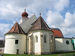
 The parish church | |
| Coordinates: 47°41′N 16°0′E | |
| Country | Austria |
| State | Lower Austria |
| District | Neunkirchen |
| Government | |
| • Mayor | Sylivia Kögler (SPÖ) |
| Area | |
| • Total | 13.9 km2 (5.4 sq mi) |
| Elevation | 430 m (1,410 ft) |
| Population (2018-01-01)[2] | |
| • Total | 2,264 |
| • Density | 160/km2 (420/sq mi) |
| Time zone | UTC+1 (CET) |
| • Summer (DST) | UTC+2 (CEST) |
| Postal code | 2632 |
| Area code | 02630 |
| Vehicle registration | NK |
| Website | www.grafenbach.at |
Grafenbach_St. Valtentin lies southwest of Ternitz in the Schwarzatal. It has an area of 13.9 km2. 15.54% of its area is forested.
In ancient times, the municipality was part of the Roman province of Noricum. There is a 9th-century burial ground near Grafenbach.
| Year | Pop. | ±% |
|---|---|---|
| 1869 | 746 | — |
| 1880 | 895 | +20.0% |
| 1890 | 1,198 | +33.9% |
| 1900 | 1,466 | +22.4% |
| 1910 | 1,755 | +19.7% |
| 1923 | 1,698 | −3.2% |
| 1934 | 1,762 | +3.8% |
| 1939 | 1,786 | +1.4% |
| 1951 | 1,746 | −2.2% |
| 1961 | 1,856 | +6.3% |
| 1971 | 2,003 | +7.9% |
| 1981 | 1,969 | −1.7% |
| 1991 | 2,233 | +13.4% |
| 2001 | 2,303 | +3.1% |
| 2011 | 2,248 | −2.4% |