Top Qs
Timeline
Chat
Perspective
Gobblers Knob (Utah)
Mountain in the American state of Utah From Wikipedia, the free encyclopedia

Remove ads
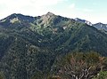
Gobblers Knob is a 10,246-foot elevation (3,123 m) mountain summit located in Salt Lake County, Utah, United States.


Remove ads
Description
Gobblers Knob is the highest point in the Mount Olympus Wilderness,[3] and is set on land managed by Wasatch National Forest. This peak is situated in the Wasatch Range which is a subset of the Rocky Mountains, and with Salt Lake City 12 miles to the west and Park City 10 miles to the east, it is a popular hiking destination.[7] Neighbors include Mount Raymond 1.5 mile to the southwest and Kesler Peak is 3.2 miles to the south. Precipitation runoff from the mountain's north slope drains to Mill Creek, whereas the south slope drains to Big Cottonwood Creek. Topographic relief is significant as the summit rises 3,240 feet (990 meters) above Mill Creek Canyon in 1.5 mile.
Remove ads
History
This mountain's toponym was officially adopted in 1964 by the United States Board on Geographic Names.[2] The landform's name "gobbler" refers to turkeys which miners of the Big Cottonwood Mining District tried raising when their mining income ceased, but this also failed as bobcats ate the turkeys.[8] In 1904, the Baker mine on the northwest slope produced gold ore and copper.[6]
Climate
See also
Gallery
 Northeast aspect
 Northwest aspect
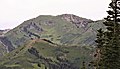 Southeast aspect
 Mount Raymond (left) and Gobblers Knob (right) from southeast
 Southeast aspect of Gobblers Knob seen from Big Cottonwood Canyon


References
External links
Wikiwand - on
Seamless Wikipedia browsing. On steroids.
Remove ads