Glendale, Mississippi
Census-designated place in Mississippi, United States From Wikipedia, the free encyclopedia
Glendale is an unincorporated community and census-designated place (CDP) located in Forrest County, Mississippi, United States. Glendale is approximately 3.5 miles (5.6 km) north of Hattiesburg on Mississippi Highway 42 and a part of the Hattiesburg, Mississippi Metropolitan Statistical Area.
Glendale, Mississippi | |
|---|---|
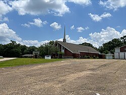
 Glendale Baptist Church | |
| Coordinates: 31°21′53″N 89°18′22″W | |
| Country | United States |
| State | Mississippi |
| County | Forrest |
| Area | |
• Total | 1.63 sq mi (4.22 km2) |
| • Land | 1.63 sq mi (4.22 km2) |
| • Water | 0.00 sq mi (0.00 km2) |
| Elevation | 167 ft (51 m) |
| Population (2020) | |
• Total | 1,681 |
| • Density | 1,031.29/sq mi (398.17/km2) |
| Time zone | UTC-6 (Central (CST)) |
| • Summer (DST) | UTC-5 (CDT) |
| ZIP code | 39402 |
| Area code | 601 |
| GNIS feature ID | 670431[2] |
As of the 2020 census, Glendale had a population of 1,681.[3]
Demographics
| Race | Number | Percentage |
|---|---|---|
| White (NH) | 538 | 32.0% |
| Black or African American (NH) | 1,013 | 60.26% |
| Native American or Alaska Native (NH) | 3 | 0.18% |
| Asian (NH) | 11 | 0.65% |
| Pacific Islander (NH) | 1 | 0.06% |
| Mixed/Multi-Racial (NH) | 60 | 3.57% |
| Hispanic or Latino | 55 | 3.27% |
| Total | 1,681 |
As of the 2020 United States census, there were 1,681 people, 624 households, and 450 families residing in the CDP.
References
Wikiwand - on
Seamless Wikipedia browsing. On steroids.

