Geomorphological division of the Czech Republic
From Wikipedia, the free encyclopedia

In terms of geomorphological division, the Czech Republic is a very diverse territory, located in the territory of four geomorphological provinces within four geomorphological subsystems. The Bohemian Massif within the sub-system of Hercynian Forest forms three quarters of the country. The southeastern and eastern part of the Czech territory belongs to the Western Carpathians within the Carpathian Mountains. The remaining two provinces, Western Pannonian Plain within the Pannonian Basin and North European Plain within the European Plain, cover only a small part of the Czech territory in the southeast and northeast.
Bohemian Massif
North European Plain
Western Carpathians
Western Pannonian Basin
The provinces are further subdivided into subprovinces, macroregions, mesoregions, microregions and areas. The generally accepted division of the relief of the Czech Republic into subprovinces, macroregions and mesoregions is given below.[1]
Maps
 Subprovinces of the Czech Republic
 Macroregions of the Czech Republic
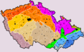 Mesoregions of the Czech Republic[a]


Basic geomorphological division
Summarize
Perspective
Note: Some mesoregions extend beyond the borders of the Czech Republic. The area, average altitude and highest point correspond to the territory of mesoregions only in the Czech Republic.
| Province | Subprovince | Macroregion | Mesoregion | Code | Area (km2)[2] | Average altitude (m ASL)[2] | Highest point (m ASL) |
|---|---|---|---|---|---|---|---|
| Bohemian Massif | Bohemian Forest Subprovince | Upper Palatine Forest Macroregion | Upper Palatine Forest (Český les) | IA-1 | 789 | 628.2 | 1042 (Čerchov) |
| Upper Palatine Forest Foothills (Podčeskoleská pahorkatina) | IA-2 | 746 | 491.1 | 679 (Chebský vršek) | |||
| Cham-Furth Depression (Všerubská vrchovina) | IA-3 | 206 | 517.0 | 751 (Kameňák) | |||
| Bohemian Forest Highlands | Bohemian Forest (Šumava) | IB-1 | 1,671 | 921.5 | 1378 (Plechý) | ||
| Bohemian Forest Foothills (Šumavské podhůří) | IB-2 | 2,407 | 634.4 | 1094 (Libín) | |||
| Gratzen Mountains (Novohradské hory) | IB-3 | 162 | 809.9 | 1073 (Kamenec) | |||
| Gratzen Foothills (Novohradské podhůří) | IB-4 | 719 | 555.8 | 871 (Kohout) | |||
| Bohemian-Moravian Subprovince | Central Bohemian Hills | Benešov Uplands (Benešovská pahorkatina) | IIA-1 | 2,410 | 366.2 | 638 (Stráž) | |
| Vlašim Uplands (Vlašimská pahorkatina) | IIA-2 | 1,232 | 492.1 | 724 (Javorová skála) | |||
| Tábor Uplands (Táborská pahorkatina) | IIA-3 | 1,599 | 449.3 | 633 (Velký Mehelník) | |||
| Blatná Uplands (Blatenská pahorkatina) | IIA-4 | 1,087 | 509.2 | 729 (Drkolná) | |||
| South Bohemian Basins | České Budějovice Basin (Českobudějovická pánev) | IIB-1 | 640 | 408.0 | 480 (Vráže) | ||
| Třeboň Basin (Třeboňská pánev) | IIB-2 | 1,360 | 457.0 | 583 (Baba) | |||
| Bohemian-Moravian Highlands | Křemešník Highlands (Křemešnická vrchovina) | IIC-1 | 2,634 | 551.5 | 769 (Křemešník) | ||
| Upper Sázava Hills (Hornosázavská pahorkatina) | IIC-2 | 1,869 | 463.0 | 661 (Roudnice) | |||
| Iron Mountains (Železné hory) | IIC-3 | 748 | 480.4 | 738 (U oběšeného) | |||
| Upper Svratka Highlands (Hornosvratecká vrchovina) | IIC-4 | 1,135 | 580.2 | 836 (Devět skal) | |||
| Křižanov Highlands (Křižanovská vrchovina) | IIC-5 | 2,722 | 541.2 | 743 (Harusův kopec) | |||
| Javořice Highlands (Javořická vrchovina) | IIC-6 | 624 | 603.5 | 837 (Javořice) | |||
| Jevišovice Uplands (Jevišovická pahorkatina) | IIC-7 | 2,010 | 414.3 | 634 (Zadní hora) | |||
| Brno Highlands | Boskovice Furrow (Boskovická brázda) | IID-1 | 409 | 354.6 | 553 (Nad Amerikou) | ||
| Bobrava Highlands (Bobravská vrchovina) | IID-2 | 371 | 316.7 | 479 (Kopeček) | |||
| Drahany Highlands (Drahanská vrchovina) | IID-3 | 1,183 | 462.8 | 735 (Skalky) | |||
| Ore Mountains Subprovince | Ore Mountains Highlands | Fichtel Mountains (Smrčiny) | IIIA-1 | 289 | 572.1 | 758 (Háj) | |
| Ore Mountains (Krušné hory) | IIIA-2 | 1,607 | 707.6 | 1244 (Klínovec) | |||
| Elbe Sandstone Mountains (Děčínská vrchovina) | IIIA-3 | 278 | 358.4 | 724 (Děčínský Sněžník) | |||
| Podkrušnohorská Macroregion | Cheb Basin (Chebská pánev) | IIIB-1 | 271 | 458.6 | 534 (Doubravský vrch) | ||
| Sokolov Basin (Sokolovská pánev) | IIIB-2 | 312 | 451.8 | 570 (Zelený vrch) | |||
| Most Basin (Mostecká pánev) | IIIB-3 | 1,105 | 272.1 | 450 (a contour line) | |||
| Doupov Mountains (Doupovské hory) | IIIB-4 | 607 | 558.2 | 934 (Hradiště) | |||
| Central Bohemian Uplands (České středohoří) | IIIB-5 | 1,265 | 362.9 | 837 (Milešovka) | |||
| Karlovy Vary Highlands | Slavkov Forest (Slavkovský les) | IIIC-1 | 559 | 661.8 | 983 (Lesný) | ||
| Teplá Highlands (Tepelská vrchovina) | IIIC-2 | 682 | 627.3 | 847 (Podhorní vrch) | |||
| Sudetes | Western Sudetes | Lusatian Highlands (Šluknovská pahorkatina) | IVA-1 | 276 | 423.4 | 608 (Hrazený) | |
| Lusatian Mountains (Lužické hory) | IVA-2 | 180 | 509.2 | 793 (Luž) | |||
| Ještěd–Kozákov Ridge (Ještědsko-kozákovský hřbet) | IVA-3 | 200 | 518.5 | 1012 (Ještěd) | |||
| Zittau Basin (Žitavská pánev) | IVA-4 | 187 | 384.2 | 593 (Prosečský hřeben) | |||
| Frýdlant Hills (Frýdlantská pahorkatina) | IVA-5 | 241 | 359.4 | 573 (Andělský vrch) | |||
| Jizera Mountains (Jizerské hory) | IVA-6 | 417 | 695.8 | 1124 (Smrk) | |||
| Giant Mountains (Krkonoše) | IVA-7 | 454 | 901.0 | 1603 (Sněžka) | |||
| Giant Mountains Foothills (Krkonošské podhůří) | IVA-8 | 1,247 | 463.2 | 839 (Hejlov) | |||
| Central Sudetes | Broumov Highlands (Broumovská vrchovina) | IVB-1 | 535 | 527.1 | 881 (Královecký Špičák) | ||
| Orlické Mountains (Orlické hory) | IVB-2 | 341 | 713.0 | 1116 (Velká Deštná) | |||
| Orlické Foothills (Podorlická pahorkatina) | IVB-3 | 1,115 | 454.1 | 841 (Špičák) | |||
| Kłodzko Valley (Kladská kotlina) | IVB-4 | 58 | 549.8 | 585 (Hůrka) | |||
| Eastern Sudetes | Zábřeh Highlands (Zábřežská vrchovina) | IVC-1 | 734 | 426.5 | 715 (Lázek) | ||
| Mohelnice Depression (Mohelnická brázda) | IVC-2 | 119 | 288.8 | 333 (Homůlka) | |||
| Hanušovice Highlands (Hanušovická vrchovina) | IVC-3 | 793 | 527.2 | 1003 (Jeřáb) | |||
| Králický Sněžník Mountains (Králický Sněžník) | IVC-4 | 76 | 930.9 | 1423 (Králický Sněžník) | |||
| Golden Mountains (Rychlebské hory) | IVC-5 | 276 | 644.7 | 1127 (Smrk) | |||
| Zlatohorská Highlands (Zlatohorská vrchovina) | IVC-6 | 527 | 495.8 | 975 (Příčný vrch) | |||
| Hrubý Jeseník | IVC-7 | 530 | 887.6 | 1491 (Praděd) | |||
| Nízký Jeseník | IVC-8 | 2,894 | 482.5 | 802 (Slunečná) | |||
| Sudeten Foreland | Vidnava Lowland (Vidnavská nížina) | IVD-1 | 47 | 270.4 | 351 (a contour line) | ||
| Žulová Hilly Land (Žulovská pahorkatina) | IVD-2 | 107 | 336.8 | 527 (Boží hora) | |||
| Poberounská Subprovince | Brdy Macroregion | Džbán | VA-1 | 311 | 416.6 | 538 (Louštín) | |
| Prague Plateau (Pražská plošina) | VA-2 | 1,128 | 302.5 | 435 (Na rovinách) | |||
| Křivoklát Highlands (Křivoklátská vrchovina) | VA-3 | 745 | 417.8 | 723 (Radeč) | |||
| Hořovice Uplands (Hořovická pahorkatina) | VA-4 | 427 | 352.7 | 499 (Bacín) | |||
| Brdy Highlands (Brdská vrchovina) | VA-5 | 827 | 556.0 | 865 (Tok) | |||
| Plzeň Uplands | Rakovník Uplands (Rakovnická pahorkatina) | VB-1 | 1,003 | 439.6 | 677 (Lišák) | ||
| Plasy Uplands (Plaská pahorkatina) | VB-2 | 2,180 | 423.3 | 704 (Vlčí hora) | |||
| Švihov Highlands (Švihovská vrchovina) | VB-3 | 1,424 | 460.3 | 773 (Koráb) | |||
| Bohemian Table | North Bohemian Table | Ralsko Uplands (Ralská pahorkatina) | VIA-1 | 1,356 | 318.2 | 698 (Ralsko) | |
| Jičín Uplands (Jičínská pahorkatina) | VIA-2 | 1,244 | 305.6 | 562 (Sokol) | |||
| Central Bohemian Table | Lower Ohře Table (Dolnooharská tabule) | VIB-1 | 1,139 | 229.2 | 461 (Říp) | ||
| Jizera Table (Jizerská tabule) | VIB-2 | 949 | 260.2 | 410 (Rokytská horka) | |||
| Central Elbe Table (Středolabská tabule) | VIB-3 | 2,266 | 215.0 | 400 (a contour line) | |||
| East Bohemian Table | East Elbe Table (Východolabská tabule) | VIC-1 | 1,689 | 251.5 | 352 (Na šancích) | ||
| Orlice Table (Orlická tabule) | VIC-2 | 966 | 290.6 | 454 (U rozhledny) | |||
| Svitavy Uplands (Svitavská pahorkatina) | VIC-3 | 1,692 | 412.2 | 693 (Baldský vrch) | |||
| North European Plain | Polish Plain | Silesian Lowlands | Opava Hilly Land (Opavská pahorkatina) | VIIA-1 | 394 | 258.3 | 340 (a contour line) |
| Western Carpathians | Outer Subcarpathia | Western Outer Subcarpathia | Dyje–Svratka Valley (Dyjsko-svratecký úval) | VIIIA-1 | 1,452 | 210.0 | 355 (Výhon) |
| Vyškov Gate (Vyškovská brána) | VIIIA-2 | 141 | 226.5 | 339 (Na hanácké) | |||
| Upper Morava Valley (Hornomoravský úval) | VIIIA-3 | 1,315 | 225.8 | 345 (Jelení vrch) | |||
| Moravian Gate (Moravská brána) | VIIIA-4 | 534 | 263.5 | 375 (a contour line) | |||
| Northern Outer Subcarpathia | Ostrava Basin (Ostravská pánev) | VIIIB-1 | 486 | 244.0 | 337 (Kouty) | ||
| Outer Western Carpathians | South-Moravian Carpathians | Mikulov Highlands (Mikulovská vrchovina) | IXA-1 | 81 | 263.4 | 550 (Děvín) | |
| Central Moravian Carpathians | Ždánice Forest (Ždánický les) | IXB-1 | 470 | 270.7 | 439 (U Slepice) | ||
| Litenčice Hills (Litenčická pahorkatina) | IXB-2 | 590 | 293.7 | 518 (Hradisko) | |||
| Chřiby | IXB-3 | 335 | 342.6 | 587 (Brdo) | |||
| Kyjov Hills (Kyjovská pahorkatina) | IXB-4 | 482 | 235.2 | 417 (Babí lom) | |||
| Slovak-Moravian Carpathians | Vizovice Highlands (Vizovická vrchovina) | IXC-1 | 1,399 | 338.7 | 753 (Klášťov) | ||
| White Carpathians (Bílé Karpaty) | IXC-2 | 575 | 473.0 | 970 (Velká Javořina) | |||
| Maple Mountains (Javorníky) | IXC-3 | 229 | 631.6 | 1019 (Malý Javorník) | |||
| Western Beskidian Foothills | Moravian-Silesian Foothills (Podbeskydská pahorkatina) | IXD-1 | 1,508 | 353.0 | 964 (Skalka) | ||
| Western Beskids | Hostýn-Vsetín Mountains (Hostýnsko-vsetínská hornatina) | IXE-1 | 629 | 552.9 | 1024 (Vysoká) | ||
| Rožnov Furrow (Rožnovská brázda) | IXE-2 | 109 | 486.5 | 576 (Poskla) | |||
| Moravian-Silesian Beskids (Moravskoslezské Beskydy) | IXE-3 | 623 | 703.3 | 1324 (Lysá hora) | |||
| Jablunkov Furrow (Jablunkovská brázda) | IXE-4 | 74 | 441.9 | 577 (a contour line) | |||
| Silesian Beskids (Slezské Beskydy) | IXE-5 | 54 | 613.7 | 995 (Velká Čantoryje) | |||
| Jablunkov Intermontane (Jablunkovské mezihoří) | IXE-6 | 26 | 592.3 | 840 (Girova) | |||
| Western Pannonian Plain | Vienna Basin | South Moravian Basin[b] | Lower Morava Valley (Dolnomoravský úval) | XA-1 | 965 | 183.2 | 322 (Žerotín) |
| Záhorie Lowland | Chvojnice Hills (Chvojnická pahorkatina) | XB-1 | 5 | 210.0 | 266 (Staré hory) |
Notes
References
Literature
External links
Wikiwand - on
Seamless Wikipedia browsing. On steroids.