Geltendorf
Municipality in Bavaria, Germany From Wikipedia, the free encyclopedia
Geltendorf (German pronunciation: [ˈɡɛltn̩ˌdɔʁf]) is a municipality in the district of Landsberg in Bavaria, Germany.
Geltendorf | |
|---|---|
 Church of Saint Stephen | |
 Coat of arms | |
Location of Geltendorf
within Landsberg am Lech district 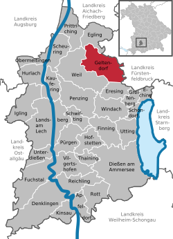 | |
 Geltendorf  Geltendorf | |
| Coordinates: 48°7′20″N 11°1′40″E | |
| Country | Germany |
| State | Bavaria |
| Admin. region | Oberbayern |
| District | Landsberg am Lech |
| Subdivisions | 8 Ortsteile |
| Government | |
| • Mayor (2020–26) | Robert Sedlmayr[1] (ÖDP) |
| Area | |
• Total | 34.81 km2 (13.44 sq mi) |
| Elevation | 603 m (1,978 ft) |
| Population (2023-12-31)[2] | |
• Total | 6,005 |
| • Density | 170/km2 (450/sq mi) |
| Time zone | UTC+01:00 (CET) |
| • Summer (DST) | UTC+02:00 (CEST) |
| Postal codes | 82269 |
| Dialling codes | 08193 |
| Vehicle registration | LL |
| Website | www.geltendorf.de |
World heritage site
It is home to one or more prehistoric pile-dwelling (or stilt house) settlements that are part of the Prehistoric Pile dwellings around the Alps UNESCO World Heritage Site.[3]
Transport
The municipality has two railway stations, Geltendorf and Walleshausen.
References
External links
Wikiwand - on
Seamless Wikipedia browsing. On steroids.