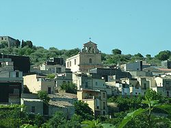
Ferla
Comune in Sicily, Italy From Wikipedia, the free encyclopedia
Comune in Sicily, Italy From Wikipedia, the free encyclopedia
Ferla (Sicilian: A Ferra) is a town and comune in the Province of Syracuse, Sicily (southern Italy). It is one of I Borghi più belli d'Italia ("The most beautiful villages of Italy").[3]
You can help expand this article with text translated from the corresponding article in Italian. (January 2022) Click [show] for important translation instructions.
|
Ferla | |
|---|---|
| Comune di Ferla | |
 Ferla | |
| Coordinates: 37°7′N 14°57′E | |
| Country | Italy |
| Region | Sicily |
| Province | Syracuse (SR) |
| Government | |
| • Mayor | Michelangelo Giansiracusa (Action) |
| Area | |
| • Total | 24.9 km2 (9.6 sq mi) |
| Elevation | 556 m (1,824 ft) |
| Population (30 November 2017)[2] | |
| • Total | 2,450 |
| • Density | 98/km2 (250/sq mi) |
| Demonym | Ferlesi |
| Time zone | UTC+1 (CET) |
| • Summer (DST) | UTC+2 (CEST) |
| Postal code | 96010 |
| Dialing code | 0931 |
| Patron saint | Saint Sebastian |
| Saint day | 20 July |
| Website | Official website |
The Necropolis of Pantalica, part of the UNESCO World Heritage Site of "Syracuse and the Rocky Necropolis of Pantalica" is situated between Ferla and Sortino.
Seamless Wikipedia browsing. On steroids.
Every time you click a link to Wikipedia, Wiktionary or Wikiquote in your browser's search results, it will show the modern Wikiwand interface.
Wikiwand extension is a five stars, simple, with minimum permission required to keep your browsing private, safe and transparent.