Extreme points of Moldova
From Wikipedia, the free encyclopedia
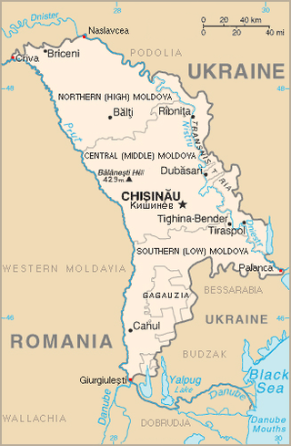
This is a list of the extreme points of Moldova: the points that are farther north, south, east or west than any other location, as well as the highest and lowest points in the country.
This article needs additional citations for verification. (November 2024) |

Extreme coordinates
| Heading | Location | District | Bordering entity | Coordinates[1] | Notes |
|---|---|---|---|---|---|
| North extreme | Naslavcea | Ocnița District | Mohyliv-Podilskyi Raion of Vinnytsia Oblast (Ukraine) | 48°29′28″N 27°35′19″E | |
| South extreme | Giurgiulești | Cahul District | Galați (Romania) & Reni (Ukraine) (Moldova/Romania/Ukraine tripoint) |
45°28′08″N 28°12′47″E | |
| West extreme | Criva | Briceni District | Păltiniș (Romania) & Dnistrovskyi Raion (Ukraine) (Moldova/Romania/Ukraine tripoint) |
48°16′27″N 26°36′59″E | |
| East extreme | Palanca | Ștefan Vodă District | Bilhorod-Dnistrovskyi Raion of Odesa Oblast (Ukraine) | 46°24′48″N 30°09′47″E |
Elevation extremes
- Highest point: Bălănești Hill at 430 m[2] (47°13′01″N 28°05′00″E)
- Lowest point: Dniester river at 2 m[2]
See also
References
Wikiwand - on
Seamless Wikipedia browsing. On steroids.
