Delta County, Michigan
County in Michigan, United States From Wikipedia, the free encyclopedia
Delta County is a county in the Upper Peninsula in the U.S. state of Michigan. As of the 2020 census, the population was 36,903.[2] The county seat is Escanaba.[3] The county was surveyed in 1843 and organized in 1861. Its name originates from the Greek letter delta (Δ), which refers to the triangular shape of the original county[1][4] which included segments of Menominee, Dickinson, Iron, and Marquette counties.[5] Recreation and forest products are major industries, and crops include hay, corn, small grains, potatoes, and strawberries.[6]
Delta County | |
|---|---|
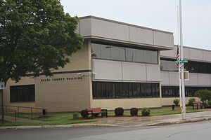
 Delta County Courthouse in Escanaba | |
 Location within the U.S. state of Michigan | |
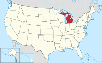
 Michigan's location within the U.S. | |
| Coordinates: 45°47′N 86°52′W | |
| Country | United States |
| State | Michigan |
| Founded | March 9, 1843 (authorized) 1861 (organized)[1] |
| Named after | Greek letter Delta |
| Seat | Escanaba |
| Largest city | Escanaba |
| Area | |
• Total | 1,991 sq mi (5,160 km2) |
| • Land | 1,171 sq mi (3,030 km2) |
| • Water | 820 sq mi (2,100 km2) 41% |
| Population (2020) | |
• Total | 36,903 |
| • Density | 32/sq mi (12/km2) |
| Time zone | UTC−5 (Eastern) |
| • Summer (DST) | UTC−4 (EDT) |
| Congressional district | 1st |
| Website | deltacountymi |
Delta County comprises the Escanaba, MI Micropolitan Statistical Area.
Geography
According to the U.S. Census Bureau, the county has a total area of 1,991 square miles (5,160 km2), of which 1,171 square miles (3,030 km2) is land and 820 square miles (2,100 km2) (41%) is water.[7] It is the fifth-largest county in Michigan by land area.
Adjacent counties
By land
- Menominee County (southwest, Central Time Zone border)
- Marquette County (northwest)
- Alger County (north)
- Schoolcraft County (east)
By water
- Leelanau County (southeast)
- Door County, Wisconsin (south, Central Time Zone border)
National protected area
- Hiawatha National Forest (part)
Communities

Cities
Village
Civil townships
Unincorporated communities
- Bark River
- Brampton
- Chaison
- Fairport
- Fayette
- Ford River[8]
- Garden Corners
- Harris
- Hyde[8]
- Isabella
- Island View[8]
- Kipling[8]
- Lake Bluff[8]
- Maplewood[8]
- Nahma
- Narenta
- Perkins
- Perronville
- Rapid River
- Riverland[8]
- Rock
- St. Nicholas[8]
- Schaffer
- Wells[8]
- West Gladstone
Indian reservations
- A small section of the Hannahville Indian Community, which has most of its territory in neighboring Menominee County to the west, extends into Bark River Township.
- The Sault Tribe of Chippewa Indians occupies a very small portion in the southwest city limits of Escanaba.
Demographics
| Census | Pop. | Note | %± |
|---|---|---|---|
| 1860 | 1,172 | — | |
| 1870 | 2,542 | 116.9% | |
| 1880 | 6,812 | 168.0% | |
| 1890 | 15,330 | 125.0% | |
| 1900 | 23,881 | 55.8% | |
| 1910 | 30,108 | 26.1% | |
| 1920 | 30,909 | 2.7% | |
| 1930 | 32,280 | 4.4% | |
| 1940 | 34,037 | 5.4% | |
| 1950 | 32,913 | −3.3% | |
| 1960 | 34,298 | 4.2% | |
| 1970 | 35,924 | 4.7% | |
| 1980 | 38,947 | 8.4% | |
| 1990 | 37,780 | −3.0% | |
| 2000 | 38,520 | 2.0% | |
| 2010 | 37,069 | −3.8% | |
| 2020 | 36,903 | −0.4% | |
| 2023 (est.) | 36,790 | [9] | −0.3% |
| US Decennial Census[10] 1790-1960[11] 1900-1990[12] 1990-2000[13] 2010-2018[2] | |||
The 2010 United States census[14] indicated Delta County had population of 37,069. By 2020, its population was 36,903.
Education
School districts include:[15]
- Bark River-Harris School District
- Big Bay de Noc School District
- Escanaba Area Public Schools
- Gladstone Area Schools
- Mid Peninsula School District
- Rapid River Public Schools
Government
Summarize
Perspective
| Year | Republican | Democratic | Third party(ies) | |||
|---|---|---|---|---|---|---|
| No. | % | No. | % | No. | % | |
| 2024 | 14,109 | 64.43% | 7,462 | 34.08% | 326 | 1.49% |
| 2020 | 13,207 | 62.39% | 7,606 | 35.93% | 354 | 1.67% |
| 2016 | 11,121 | 59.81% | 6,436 | 34.61% | 1,037 | 5.58% |
| 2012 | 9,534 | 52.59% | 8,330 | 45.95% | 266 | 1.47% |
| 2008 | 8,763 | 45.97% | 9,974 | 52.32% | 327 | 1.72% |
| 2004 | 9,680 | 50.32% | 9,381 | 48.76% | 177 | 0.92% |
| 2000 | 8,871 | 51.23% | 7,970 | 46.03% | 475 | 2.74% |
| 1996 | 5,925 | 36.69% | 8,561 | 53.01% | 1,664 | 10.30% |
| 1992 | 6,027 | 33.55% | 8,387 | 46.69% | 3,548 | 19.75% |
| 1988 | 7,114 | 44.28% | 8,891 | 55.34% | 60 | 0.37% |
| 1984 | 8,952 | 52.84% | 7,934 | 46.83% | 56 | 0.33% |
| 1980 | 8,146 | 46.04% | 8,475 | 47.90% | 1,071 | 6.05% |
| 1976 | 7,809 | 45.85% | 9,027 | 53.00% | 197 | 1.16% |
| 1972 | 7,647 | 48.14% | 8,003 | 50.38% | 236 | 1.49% |
| 1968 | 5,829 | 40.58% | 7,821 | 54.45% | 714 | 4.97% |
| 1964 | 4,434 | 30.56% | 10,046 | 69.25% | 27 | 0.19% |
| 1960 | 6,460 | 44.82% | 7,924 | 54.98% | 29 | 0.20% |
| 1956 | 7,766 | 54.31% | 6,489 | 45.38% | 45 | 0.31% |
| 1952 | 7,488 | 51.79% | 6,921 | 47.87% | 49 | 0.34% |
| 1948 | 5,414 | 42.86% | 6,943 | 54.96% | 276 | 2.18% |
| 1944 | 5,213 | 41.23% | 7,375 | 58.33% | 56 | 0.44% |
| 1940 | 6,218 | 41.18% | 8,802 | 58.29% | 81 | 0.54% |
| 1936 | 4,527 | 32.83% | 8,954 | 64.93% | 310 | 2.25% |
| 1932 | 4,386 | 35.70% | 7,363 | 59.93% | 536 | 4.36% |
| 1928 | 5,420 | 49.59% | 5,419 | 49.58% | 91 | 0.83% |
| 1924 | 4,761 | 49.83% | 463 | 4.85% | 4,330 | 45.32% |
| 1920 | 4,938 | 65.40% | 1,985 | 26.29% | 627 | 8.30% |
| 1916 | 3,088 | 59.74% | 1,781 | 34.46% | 300 | 5.80% |
| 1912 | 1,111 | 25.38% | 1,066 | 24.35% | 2,201 | 50.27% |
| 1908 | 3,243 | 71.70% | 1,097 | 24.25% | 183 | 4.05% |
| 1904 | 3,332 | 79.88% | 658 | 15.78% | 181 | 4.34% |
| 1900 | 3,081 | 70.94% | 1,210 | 27.86% | 52 | 1.20% |
| 1896 | 2,774 | 67.81% | 1,237 | 30.24% | 80 | 1.96% |
| 1892 | 1,769 | 54.30% | 1,412 | 43.34% | 77 | 2.36% |
| 1888 | 1,587 | 54.16% | 1,332 | 45.46% | 11 | 0.38% |
| 1884 | 1,201 | 66.13% | 609 | 33.54% | 6 | 0.33% |
Delta County operates the County jail, maintains rural roads, operates the major local courts, records deeds, mortgages, and vital records, administers public health regulations, and participates with the state in the provision of social services. The county board of commissioners controls the budget and has limited authority to make laws or ordinances. In Michigan, most local government functions – police and fire, building and zoning, tax assessment, street maintenance etc. – are the responsibility of individual cities and townships.
Elected officials
- Prosecuting Attorney: Lauren Wickman
- Sheriff: Edward Oswald
- County Clerk/Register of Deeds: Nancy Przewrocki
- County Treasurer: Sherry Godfrey
- Drain Commissioner: George Maciejewski
- County Surveyor: Mel Davis
- Circuit Court Judge: John B. Economopoulos
- District Court Judge: Steven C. Parks
- Probate Court Judge: Perry R. Lund
(information as of September 2018)[17]
Transportation
Major highways
 US 2 runs east–west through the lower part of the county, entering from Schoolcraft County east of Garden Corners and running westward to an intersection with US 41 at Rapid River.
 US 41 runs north–south through central part of the county, entering from Alger County at Trenary, running southerly to Rapid River then southwesterly along the Lake Michigan shore to the southwest corner of county.
 M-35 enters from Marquette County at the northwest corner of the county and runs southeasterly to intersection with US 41 at Gladstone.
 M-69 runs east–west across the southwestern tip of the county, entering from Menominee County at Schaffer and running southeasterly to an intersection with US 41 west of Narenta.
 M-183 runs from the southern tip of the Garden Peninsula at Fayette State Park to an intersection with US 2 at Garden Corners.[8]
Airport
The county is served by Delta County Airport (KESC), southwest of Escanaba. It provides scheduled airline service to Detroit and Minneapolis.
See also
References
External links
Wikiwand - on
Seamless Wikipedia browsing. On steroids.
