Eastern Indonesia
Region of Indonesia From Wikipedia, the free encyclopedia
Eastern Indonesia (or East Indonesia)[3] is one of the two main geographical regions of Indonesia, the other being Western Indonesia.[1] It comprises four geographical units: Lesser Sunda Islands, Sulawesi, Maluku Islands and Papua. Central Indonesian Time and Eastern Indonesia Time are the national standard time designated for Eastern Indonesia; it falls within the UTC+8 and UTC+9 time zone, respectively.
This article needs additional citations for verification. (November 2023) |
Eastern Indonesia | |
|---|---|
| Kawasan Timur Indonesia[1] Indonesia Timur (in Indonesian) | |
|
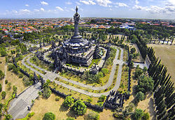
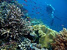
From upper-left to lower-right: Diving experience in Piaynemo Island of Raja Ampat, Clitoria ternatea (the native flower of Ternate Island), Pura Ulun Danu Bratan, Bali (Bali's most popular Hindu temple) Papeda (the staple food of Eastern Indonesia) | |
 Eastern Region of Indonesia | |
| Largest city | Makassar |
| Provinces | 17 Provinces |
| Demonym | Eastern Indonesians[2] |
| Time zones | UTC+8 (Central Indonesia Time) |
| UTC+9 (Eastern Indonesia Time) | |
Eastern Indonesia borders the Southern Philippines and Palau in the North, Papua New Guinea in the East, and Northern Australia in the South.
History and background
During the last stages of the Dutch colonial era, the area east of Java and Kalimantan was known as the Great East and later known as Eastern Indonesia. After Denpasar Conference, on 24 December 1946, the State of East Indonesia was formed covering the same area, excluding Western New Guinea, previously included during Malino Conference. It was a component of the United States of Indonesia, and was dissolved into the unitary Republic of Indonesia in 17 August 1950.[4] Currently, Eastern Indonesia consists of 17 provinces: Bali, East Nusa Tenggara, West Nusa Tenggara, Central Sulawesi, Gorontalo, North Sulawesi, South Sulawesi, Southeast Sulawesi, West Sulawesi, Maluku, North Maluku, Central Papua, Highland Papua, Papua, South Papua, Southwest Papua, and West Papua.[5][6][7]
Geography
This section needs expansion. You can help by adding to it. (November 2023) |
Climate
In Eastern Indonesia, the days are generally dry and sunny from October through March with the warm tropical rain season occurring between May and August; temperatures are typically in the 27 °C (81 °F) to 30 °C (86 °F) range throughout the year.[8]
Administration

Administratively, Eastern Indonesia consists of four main geographical units, namely the Lesser Sunda Islands, Sulawesi, Maluku Islands and Papua.
| ISO 3166-2 Codes | Geographical unit | Provinces | Population (mid-2022)[9] |
Largest city | Highest point |
|---|---|---|---|---|---|
ID-NU |
Nusa Tenggara (Lesser Sunda Islands) | Bali, West Nusa Tenggara, and East Nusa Tenggara | 15,355,100 | Denpasar | Mount Rinjani
3,726 m (12,224 ft) |
ID-SL |
Sulawesi | Central Sulawesi, Gorontalo, North Sulawesi, South Sulawesi, Southeast Sulawesi, and West Sulawesi | 20,304,400 | Makassar | Latimojong
3,478 m (11,411 ft) |
ID-ML |
Maluku Islands | Maluku and North Maluku | 3,201,000 | Ambon | Mount Binaiya 3,027 m (9,931 ft) |
ID-PP |
Papua | Central Papua, Highland Papua, Papua, South Papua, Southwest Papua, and West Papua | 5,601,900 | Jayapura | Puncak Jaya 4,884 m (16,024 ft) |
Economy
This section needs expansion. You can help by adding to it. (November 2023) |
Seaweed farming has traditionally been a common commercial activity along the coasts of Eastern Indonesia; however, in the 2020s climate change in Indonesia has been causing seaweed farmers in Eastern Indonesia to lose revenue and harvests.[10] In the consumer shopping industry, Eastern Indonesia experienced a rapid increase in online shopping in the 2020s, with overall transactions in the region doubling from 2020 to 2021; this growth has been led by Indonesian e-commerce company Tokopedia, with the top product types sold in the region being health and beauty, fashion, food and beverage, and electronics.[11]
Demographics
This section needs expansion. You can help by adding to it. (November 2023) |
Largest cities
The following are the four largest cities in Eastern Indonesia by population:
| No. | City | Province | Population | Image |
|---|---|---|---|---|
| 1. | Makassar | South Sulawesi | 1.571.814 |  |
| 2. | Denpasar | Bali | 725.314 |  |
| 3. | Manado | North Sulawesi | 478.192 |  |
| 4. | Kupang | East Nusa Tenggara | 442.758 |  |
| 5. | Mataram | West Nusa Tenggara | 452.812 |  |
| 6. | Jayapura | Papua | 398.478 |  |
| 7. | Palu | Central Sulawesi | 373.218 |  |
| 8. | Ambon | Maluku | 347.288 |  |
| 9. | Kendari | Southeast Sulawesi | 347.381 |  |
| 10. | Sorong | Southwest Papua | 284.410 |  |
See also
References
Bibliography
External links
Wikiwand - on
Seamless Wikipedia browsing. On steroids.


