Drogeham
Village in Friesland, Netherlands From Wikipedia, the free encyclopedia
Drogeham (West Frisian: Droegeham) is a village of about 1,700 inhabitants[3] in the Dutch province of Friesland.
Drogeham
| |
|---|---|
Village | |
 Walburga Church | |
 Flag  Coat of arms | |
 Location in Achtkarspelen municipality | |
 Drogeham Location in the Netherlands  Drogeham Drogeham (Netherlands) | |
| Coordinates: 53.20169°N 6.11207°E | |
| Country | Netherlands |
| Province | Friesland |
| Municipality | Achtkarspelen |
| Area | |
• Total | 10.42 km2 (4.02 sq mi) |
| Elevation | 3 m (10 ft) |
| Population (2021)[1] | |
• Total | 1,725 |
| • Density | 170/km2 (430/sq mi) |
| Time zone | UTC+1 (CET) |
| • Summer (DST) | UTC+2 (CEST) |
| Postal code | 9289[1] |
| Dialing code | 0512 |
| Website | drogeham |
It is in a rural area of the municipality of Achtkarspelen. Agriculture still plays an important part in the town, but small-scale industry is on the increase. Many people have their jobs in nearby larger towns like Drachten, Surhuisterveen, and Leeuwarden. The most common language is still West Frisian although there are more and more people coming to Drogeham who have Dutch as their mother-tongue.
History
The village was first mentioned in 1475 as Asterham, Drogheham, and means dry land in a bend of a stream.[4] Drogeham developed to the west of the monastery of Buweklooster. The tower of the Protestant church of Drogeham dates from circa 1225 and was restored in 1704. The church itself extensively modified in 1876.[5][6] In 1840, Drogeham was home to 264 people.[6]
Notable buildings
Gallery
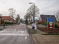 Welcome to Drogeham
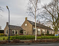 Former school
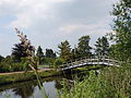 Bridge over the canal
 Former pub


References
External links
Wikiwand - on
Seamless Wikipedia browsing. On steroids.