Konaseema district
District in Andhra Pradesh, India From Wikipedia, the free encyclopedia
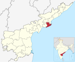
Konaseema district (officially Dr. B. R. Ambedkar Konaseema district) is a district in Konaseema region of Andhra Pradesh in India. It is situated between the tributaries of the Godavari River in the Coastal Andhra. It was carved out of East Godavari district on 4 April 2022 by the Government of Andhra Pradesh. Amalapuram is the district headquarters and the largest city in this district. The district shares boundaries with West Godavari, East Godavari and Kakinada districts.
Konaseema district | |
|---|---|
| Dr. B. R. Ambedkar Konaseema district | |
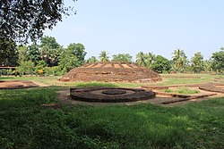
Clockwise from top-left: Bhimeswara temple at Draksharama, Crop fields in Yeditha, Street of Amalapuram, Antarvedi Beach, Gummileru Jain Temple | |
 Location of Konaseema district in Andhra Pradesh | |
 Interactive map outlining district | |
| Coordinates: 16.6°N 82.0°E | |
| Country | India |
| State | Andhra Pradesh |
| Region | Coastal Andhra |
| Formed | 4 April 2022 |
| Founded by | Government of Andhra Pradesh |
| Headquarters | Amalapuram |
| Government | |
| • District collector | Mahesh Kumar IAS |
| • Superintendent of Police | P Sridhar IPS[1] |
| • Lok Sabha constituencies | 01 |
| • Assembly constituencies | 07 |
| Area | |
• Total | 2,081.2 km2 (803.6 sq mi) |
| Population (2011)[2] | |
• Total | 1,719,093 |
| • Density | 830/km2 (2,100/sq mi) |
| Languages | |
| • Official | Telugu |
| Time zone | UTC+05:30 (IST) |
| Website | konaseema |
Geography
Dr. B. R. Ambedkar Konaseema district is situated in the delta of the Godavari River. The land in this region is considered highly fertile, and its economy is primarily based on agriculture,[3] especially with a focus on rice and coconut cultivation.[4] Mangrove forests are present in the northeast of the district.[5] Apart from the Ramachandrapuram revenue division, the district lies between the two branches of the Godavari River. The Godavari divides into two components, namely Gautami and Vasishtha,[6] forming an island which is called Konaseema.[7]
This district is surrounded to the north by East Godavari district, south by the Bay of Bengal, east by Kakinada district and west by West Godavari district.[8]
History
Summarize
Perspective
On 26 January 2022 the Andhra Pradesh Cabinet made a significant decision to create 13 new districts, and among them, the proposal for the Konaseema district was approved.[9][10] On 4 April 2022 the chief minister Y. S. Jagan Mohan Reddy virtually inaugurated all 13 new districts, officially establishing Konaseema district.[11][12] However, on 18 May 2022, the government initiated discussions about renaming Konaseema district in honour of B. R. Ambedkar, leading to violent protests on 24 May 2022, during which protesters set ablaze the home of transport minister Pinipe Viswarup.[13][14] Subsequently, on 24 June 2022, the Andhra Pradesh Cabinet endorsed the gazette notification issued on May 18, officially approving the renaming of the district.[15][16][17] Finally, on 2 August 2022, Konaseema district was officially renamed to Dr. B. R. Ambedkar Konaseema district. The change took effect on that date, as announced in the gazette notification by the Governor of Andhra Pradesh.
The notification stated:
the Governor of Andhra Pradesh, in the interests of public, after having published proposals in that regard as required under sub-section (5) of Section 3 of the Andhra Pradesh Districts (formation) Act, 1974 (Act No.7 of 1974), and having taken into consideration the objections and suggestions received thereon all persons in the areas concerned and likely to be affected thereby, do hereby notify to change the existing name of the Konaseema district as Dr. B. R. Ambedkar Konaseema district[18]
Politics
There is one parliamentary and seven assembly constituencies in the Dr. B. R. Ambedkar Konaseema district. The parliamentary constituency is Amalapuram (Lok Sabha constituency), and the assembly constituencies are listed below.[19]
| Constituency number | Name | Reserved for (SC/ST/None) |
Parliament |
|---|---|---|---|
| 42 | Ramachandrapuram | None | Amalapuram |
| 43 | Mummidivaram | None | |
| 44 | Amalapuram | SC | |
| 45 | Razole | SC | |
| 46 | Gannavaram | SC | |
| 47 | Kothapeta | None | |
| 48 | Mandapeta | None |
Administrative divisions

The district is divided into 3 revenue divisions: Amalapuram, Kothapeta and Ramachandrapuram, each of which is further subdivided into a total of 22 mandals, with each mandal being headed by a sub-collector.[20]
Mandals
The list of 22 mandals in Dr. B. R. Ambedkar Konaseema district,[21] divided into 3 revenue divisions, is given below.[22]
Cities and towns
The district underwent reorganization in 2022, resulting in the presence of one Grade 1 municipality,[23] two Grade 2 municipalities,[24] and one Nagar Panchayat.[25]
| Largest towns and villages in Dr. B. R. Ambedkar Konaseema district | ||||
|---|---|---|---|---|
| Rank | Name | Revenue division | Civil Status | Population |
| 1 | Mandapeta | Ramachandrapuram | Municipality Grade - 2 | 65,406 |
| 2 | Amalapuram | Amalapuram | Municipality Grade - 1 | 53,231 |
| 3 | Ramachandrapuram | Ramachandrapuram | Municipality Grade - 2 | 43,657 |
| 4 | Mummidivaram | Amalapuram | Nagar Panchayat | 25,355 |
| 5 | Kothapeta | Kothapeta | Gram Panchayat | 24,539 |
| 6 | Rayavaram | Ramachandrapuram | Gram Panchayat | 17,361 |
| 7 | Razole | Amalapuram | Gram Panchayat | 13,597 |
| 8 | Bandarulanka | Amalapuram | Gram Panchayat | 11,470 |
| 9 | Alamur | Kothapeta | Gram Panchayat | 9,723 |
| 10 | P.Gannavaram | Kothapeta | Gram Panchayat | 9,459 |
Demographics
| Religions in Konaseema district (2011)[26] | ||||
|---|---|---|---|---|
| Religion | Percent | |||
| Hinduism | 97.41% | |||
| Christianity | 1.39% | |||
| Islam | 1.04% | |||
| Other or not stated | 0.16% | |||
| Distribution of religions | ||||
At the time of the 2011 census, Dr. B. R. Ambedkar Konaseema district had a population of 1,719,093, of which 164,421 (9.56%) lived in urban areas. Konaseema district had a sex ratio of 994 females per 1000 males.[27] Scheduled Castes and Scheduled Tribes comprised 427,130 (24.85%) and 13,481 (0.78%).[2]
Telugu is the predominant language, spoken by 99.41% of the population.[28]
Culture

The region has a diverse folk culture with their regional gods. In the heart of the Godavari Delta, Konaseema is one of the only two regions in India, apart from Kerala, where a large community still practices traditional Shrauta rituals. These traditions have largely fallen out of use in the rest of India, making it a favoured destination for scholars seeking to understand ancient Vedic culture.[29] Most of the Dalits, like in most of Coastal Andhra, are Christians - both Catholic and Protestant.[30]
Sankranti is observed as the major festival in the Konaseema region. The people of Konaseema commemorate the 400-year-old tradition of 'Prabhala Teertham' on Kanuma, the third day of the Sankranti festival.[31] This unique celebration is set to gain national attention as a tableau representing the Konaseema festival will feature in the Republic Day parade in New Delhi on January 26.[32]
Tourism
Dr. B. R. Ambedkar Konaseema district boasts numerous tourist attractions, including the picturesque Antarvedi, Chirra Yanam, and Odalarevu beaches.[33][34][35] A notable 2nd-century CE Buddhist archaeological site can be found in Adurru village.[36] Additionally, the Andhra Pradesh Tourism Development Corporation operates resorts in Dindi, providing tourists with the opportunity to indulge in the scenic beauty of the Konaseema backwaters.[37]
Among the district's religious landmarks, Sri Vighneswara Swamy Devasthanam in Ainavilli,[38] Lord Venkateshwara Temple in Appanapalli,[39] Lakshmi Narasimha Temple in Antarvedi,[40] and Bhimeswara Swamy Temple in Draksharamam[41] are renowned for their cultural and historical significance.
Tourist attractions in Dr. B. R. Ambedkar Konaseema district
Transportation
Summarize
Perspective
Road
Dr. B. R. Ambedkar Konaseema district has efficient connectivity through state and national highways, namely NH216, NH216A, and NH216E, which diverge from NH16 and pass through the region.[42][43] Furthermore, APSRTC has bus depots in Amalapuram, Ravulapalem, and Ramachandrapuram,[44] operating bus services to villages within the district and connecting to various towns and cities in Andhra Pradesh and Telangana.[45]
Railway
The district is currently served by four railway stations. Dwarapudi railway station and Kesavaram railway station on the Howrah-Chennai main line, and Kotipalli railway station and Ramachandrapuram railway station[46] on the Kakinada - Kotipalli line. Additionally, the Kakinada - Kotipalli - Narsapur railway line is currently under construction, including the development of a bridge over the Godavari river.[47] Upon completion, this railway line will include a stop at the district headquarters, Amalapuram railway station, enhancing connectivity in the region.[48][49] Among the major railway stations in proximity to the district are Rajahmundry railway station and Narasapur railway station.
Air
The district lacks airport, with the closest domestic options being Rajahmundry Airport at a distance of 75.5 kilometres (46.9 mi) and Vijayawada Airport at 170 kilometres (110 mi) from the district headquarters, Amalapuram. For international travel, the nearest airports are Visakhapatnam Airport, situated 219 kilometres (136 mi) away, and Rajiv Gandhi International Airport, located 474 kilometres (295 mi) away.[50][51]
See also
References
External links
Wikiwand - on
Seamless Wikipedia browsing. On steroids.


