Top Qs
Timeline
Chat
Perspective
Don Salvador Benedicto
Municipality in Negros Occidental, Philippines From Wikipedia, the free encyclopedia
Remove ads
Don Salvador Benedicto, officially the Municipality of Don Salvador Benedicto (Hiligaynon: Banwa sang Don Salvador Benedicto; Tagalog: Bayan ng Don Salvador Benedicto) or simply Salvador Benedicto and abbreviated as DSB, is a municipality in the province of Negros Occidental, Philippines. According to the 2020 census, it has a population of 26,922 people.[3]
Remove ads
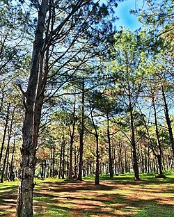
The municipality is a post-colonial provincial hill station, designated the Summer Capital of Negros Occidental, and is a popular tourist site.[5]
Remove ads
History
Summarize
Perspective
The idea for the creation of the municipality originated from Nehemias “Nene” de la Cruz, a political dissident who was imprisoned during the Martial law era. While in prison, he began dreaming of creating a town out of the “cradle of insurgency/rebellion”, and after his release, gained the support of his friend Mike Coronel, who was also the provincial commander of the Philippine Constabulary in Negros Occidental, in establishing the upcoming municipality based in Barangay Igmaya-an, which was then part of Murcia, in 1976. Located at the center of the mountains of northern Negros Occidental, Don Salvador Benedicto was chartered in 1983 through Batas Pambansa Bilang 336 by then President Ferdinand Marcos. It consolidated all the remote barangays of San Carlos City and the towns of Calatrava and Murcia.[6] which were apparently neglected due to inaccessibility.[citation needed]
The town is named after the former Vice Governor Salvador Valois Benedicto (March 31, 1889–November 28, 1956) who played an important role in the setting up of a Revolutionary Government in Negros Island particularly in Barangay Igmaya-an, when the country was occupied by the Japanese during World War II.[6] He was also the main guerrilla coordinator in both Negros Oriental and Negros Occidental during the said war. Salvador Benedicto is a relative of Roberto Benedicto, a crony of Marcos.[citation needed]
- DSB Tourism Marker
- Overlooking view at DSB
Remove ads
Geography
Don Salvador Benedicto is 47 kilometres (29 mi) east of Bacolod, via Negros Occidental Eco-Tourism Highway (N69) and 53 kilometres (33 mi) from Calatrava.
Barangays
Don Salvador Benedicto is politically subdivided into 7 barangays. Each barangay consists of puroks and some have sitios.
- Bago (Lalung)
- Bagong Silang (Marcelo)
- Bunga
- Igmaya-an
- Kumaliskis
- Pandanon
- Pinowayan (Prosperidad)
Climate
Remove ads
Demographics
Languages
Major languages are Hiligaynon, followed by Cebuano. English and Tagalog are also understood.
Economy
Poverty incidence of Don Salvador Benedicto
10
20
30
40
50
60
2000
57.97 2003
50.45 2006
50.10 2009
55.85 2012
40.65 2015
25.86 2018
32.40 2021
38.29 Source: Philippine Statistics Authority[12][13][14][15][16][17][18][19] |
Although a small town, the town of Don Salvador Benedicto has seen a rise in its municipal economy thanks to tourism and local agriculture. Due to its high altitude like Baguio, the town can support crops that grow in temperate areas, making it ideal for a multitude of farming businesses. Tourism is on the rise for the town especially when travellers head out into the heart of the province. Also located in the municipality are the Choco Hills, similar to Bohol's Chocolate Hills, with shared boundary of Barangay Prosperidad, San Carlos City.[20]
Remove ads
See also

References
External links
Wikiwand - on
Seamless Wikipedia browsing. On steroids.
Remove ads


