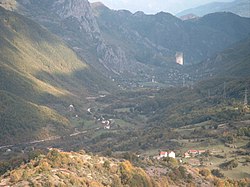
Doljani, Jablanica
Village in Federation of Bosnia and Herzegovina, Bosnia and Herzegovina From Wikipedia, the free encyclopedia
Village in Federation of Bosnia and Herzegovina, Bosnia and Herzegovina From Wikipedia, the free encyclopedia
Doljani is populated place in Jablanica Municipality, Bosnia and Hercegovina, between Jablanica and Mostar. This village lies along the Doljanka river (which was named after it) Doljani are located in the northern Herzegovina, in the northeastern part of the Nature Park "Blidinje". Elevation ranges from 600 to 750 meters in the place. The highest peaks that surround the village are Baćin (1,282 m), Borovinka (1430 m), and Vitlenica (1655 m) Throughout the Doljani valley flowing the river Doljanka.[1][2]
Doljani
Дољани | |
|---|---|
Village | |
 The view from the Obruč (Rim) | |
| Coordinates: 43°41′38″N 17°39′37″E | |
| Country | |
| Entity | Federation of Bosnia and Herzegovina |
| Canton | |
| Municipality | |
| Area | |
| • Total | 18.56 sq mi (48.07 km2) |
| Population (2013) | |
| • Total | 483 |
| • Density | 26/sq mi (10/km2) |
| Time zone | UTC+1 (CET) |
| • Summer (DST) | UTC+2 (CEST) |
| Census Year | 1991 | 1981 | 1971 |
|---|---|---|---|
| Croats | 708 (67,49%) | 731 (69,68%) | 754 (71,80%) |
| Bosniaks | 326 (31,07%) | 316 (30,12%) | 294 (28,00%) |
| Serbs | 0 | 1 (0,09%) | 1 (0,09%) |
| Yugoslavians | 10 (0,95%) | 0 | 0 |
| Others and unknown | 5 (0,47%) | 1 (0,09%) | 1 (0,09%) |
| Total | 1,049 | 1,049 | 1.050 |
According to the 2013 census, its population was 483.[4]
Seamless Wikipedia browsing. On steroids.
Every time you click a link to Wikipedia, Wiktionary or Wikiquote in your browser's search results, it will show the modern Wikiwand interface.
Wikiwand extension is a five stars, simple, with minimum permission required to keep your browsing private, safe and transparent.