Division No. 10, Newfoundland and Labrador
Census division in Newfoundland and Labrador, Canada From Wikipedia, the free encyclopedia
Census Division No. 10 of Newfoundland and Labrador is composed of the Labrador region of the province, excluding Nunatsiavut. It has a land area of 199,703 km² (77,105.8 sq mi) and at the 2016 census had a population of 24,639,[1] up from 24,111 in 2011.[2] Its two major population centres are the towns of Happy Valley-Goose Bay[3] and Labrador City.
Division No. 10 | |
|---|---|
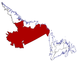
 Location of Division No. 10 in Newfoundland and Labrador | |
| Coordinates: 52°57′N 66°55′W | |
| Country | Canada |
| Province | Newfoundland and Labrador |
| Area | |
• Total | 199,703.36 km2 (77,105.90 sq mi) |
| As of 2016 | |
| Population (2016)[1] | |
• Total | 24,639 |
| • Density | 0.12/km2 (0.32/sq mi) |
Demographics
In the 2021 Census of Population conducted by Statistics Canada, Division No. 10 had a population of 24,332 living in 9,518 of its 10,941 total private dwellings, a change of -1.2% from its 2016 population of 24,639. With a land area of 191,691.09 km2 (74,012.34 sq mi), it had a population density of 0.1/km2 (0.3/sq mi) in 2021.[4]
| Ethnic Origin | Percentage of Population |
|---|---|
| Canadian | 41.8% |
| English | 30.4% |
| First Nations (North American Indian) | 15.8% |
| Inuit | 14.8% |
| Métis | 13.6% |
| Irish | 12.5% |
| Scottish | 7.1% |
| French | 6.4% |
| German | 1.8% |
| British Isles origins, not included elsewhere | 0.9% |
| Newfoundlander | 0.8% |
Towns
Unorganized subdivisions
- Subdivision A (Includes: L'Anse-Amour, Capstan Island)
- Subdivision B (Includes: Lodge Bay, Paradise River, Black Tickle, Norman's Bay, Pinsent's Arm, William's Harbour)
- Subdivision C (Includes: Sheshatshiu, Mud Lake)
- Subdivision D (Includes: Churchill Falls)
- Subdivision E (Includes: Natuashish)
References
Sources
Wikiwand - on
Seamless Wikipedia browsing. On steroids.
