Districts of Botswana
From Wikipedia, the free encyclopedia
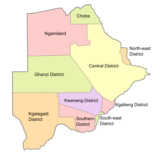
Botswana is divided into ten administrative districts, two cities, and five towns. These are administered by 17 local authorities (district councils, city councils or town councils).[1][2]
| Administrative District | Capital | Population 2022 | Area (km2) | Density (/km2) |
|---|---|---|---|---|
| Southern District | Kanye | 221,928 | 28,470 | 7.7952 |
| South-East District | Ramotswa | 111,440 | 1,780 | 62.61 |
| Kweneng District | Molepolole | 387,983 | 31,100 | 12.475 |
| Kgatleng District | Mochudi | 121,882 | 7,960 | 15.312 |
| Central District | Serowe | 652,085 | 147,730 | 4.41403 |
| North-East District | Masunga | 69,352 | 5,120 | 13.545 |
| Chobe District | Kasane | 28,743 | 20,800 | 1.382 |
| North-West District | Maun | 198,436 | 109,130 | 1.81835 |
| Ghanzi District | Ghanzi | 56,555 | 117,910 | 0.479645 |
| Kgalagadi District | Tsabong | 58,857 | 105,200 | 0.55948 |
| Districts of Botswana | |
|---|---|
 Districts of Botswana. The seven urban districts are not shown. Districts of Botswana. The seven urban districts are not shown. | |
| Category | Unitary State |
| Location | Republic of Botswana |
| Number | 17 Districts |
| Populations | 2,914 (Sowa) – 652,085 (Central District) |
| Areas | 17 km2 (6.6 sq mi) (Orapa) – 147,730 km2 (57,040 sq mi) (Central District) |
| Government |
|
| Subdivisions | |
As well as the main districts, Botswana also has seven urban districts which comprise the area of cities and towns.
| Urban District | Population 2022 | |
|---|---|---|
| Gaborone city | 246,325 | |
| Francistown city | 103,417 | |
| Lobatse town | 29,772 | |
| Selebi-Phikwe town | 42,488 | |
| Orapa town | 8,648 | |
| Jwaneng town | 18,784 | |
| Sowa town | 2,914 | |
See also
References
Wikiwand - on
Seamless Wikipedia browsing. On steroids.
