Dinkelscherben
Municipality in Bavaria, Germany From Wikipedia, the free encyclopedia
Dinkelscherben (German pronunciation: [ˈdɪŋkl̩ˌʃɛʁbn̩]) is a municipality in the district of Augsburg in Bavaria in Germany. Fleinhausen, Anried, Breitenbronn, Ettelried, Grünenbaindt, Häder, Lindach, Oberschöneberg and Ried are villages that make up the municipality of Dinkelscherben.
Dinkelscherben | |
|---|---|
 Town hall | |
 Coat of arms | |
Location of Dinkelscherben
within Augsburg district 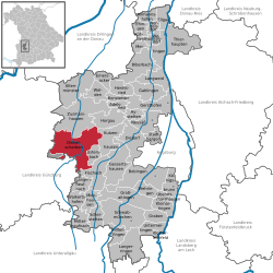 | |
 Dinkelscherben  Dinkelscherben | |
| Coordinates: 48°21′N 10°35′E | |
| Country | Germany |
| State | Bavaria |
| Admin. region | Schwaben |
| District | Augsburg |
| Government | |
| • Mayor (2020–26) | Edgar Kalb[1] |
| Area | |
• Total | 67.70 km2 (26.14 sq mi) |
| Elevation | 460 m (1,510 ft) |
| Population (2023-12-31)[2] | |
• Total | 6,819 |
| • Density | 100/km2 (260/sq mi) |
| Time zone | UTC+01:00 (CET) |
| • Summer (DST) | UTC+02:00 (CEST) |
| Postal codes | 86424 |
| Dialling codes | 08292 |
| Vehicle registration | A |
| Website | www.dinkelscherben.de |
Transport
Dinkelscherben is served by the Ulm-Augsburg railway.
References
Wikiwand - on
Seamless Wikipedia browsing. On steroids.