Demerara-Mahaica
Region of Guyana From Wikipedia, the free encyclopedia
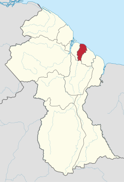
Demerara-Mahaica (Region 4) is a region of Guyana, bordering the Atlantic Ocean to the north, the region of Mahaica-Berbice to the east, the region of Upper Demerara-Berbice to the south and the region of Essequibo Islands-West Demerara to the west.
It contains the country's capital Georgetown. Notable villages in the region include Buxton, Enmore, Victoria and Paradise.
Population
The Government of Guyana has administered three official censuses since the 1980 administrative reforms, in 1980, 1991 and 2002.[4] Even though this administrative region is the smallest, it has the largest population out of all Guyana's Administrative Regions. In 2012, the population of Demerara-Mahaica was recorded at 313,429 people.[5] Official census records for the population of the Demerara-Mahaica region are as follows:
- 2012 : 401,376
- 2002 : 310,320
- 1991 : 296,924
- 1980 : 317,475
Communities
With name variants in parentheses.[6]
- Ann's Grove
- Agricola Village
- Alberttown (ward of Georgetown)
- Albouystown (ward of Georgetown)
- Alexander Village (Alexanderville)
- Annandale
- Bagotstown
- Beehive
- Bel Air (Gardens / Park / Springs) (wards of Georgetown)
- Belfield (Belfield Village)
- Beterverwagting (Betterverwagting)
- Better Hope
- Bourda
- Buxton
- Campbelville
- Cane Grove
- Charlestown (ward of Georgetown)
- Clonbrook
- Cove and John
- Craig
- Zeeland
- De Kinderen (De Kindern)
- Enmore
- Enterprise
- Georgetown
- Glasgow (Glasgow Village)
- Good Intent
- Great Diamond
- Helena
- Houston
- Hyde Park
- Jonestown (Voorzigtigheid)
- Kingston, Guyana
- Kitty (ward of Georgetown)
- Kuru Kururu
- La Penitence (ward of Georgetown)
- Lacytown (ward of Georgetown)
- Lamaha Gardens
- Land of Canaan
- Little Diamond
- Lodge (Lodge Village)
- Lusignan
- Mahaica Village
- Mon Repos
- Nabacalis (Nabaclis)
- New Burg (Newburg)
- New Haven
- Newtown (ward of Georgetown)
- Non Pariel (Nonpareil)
- Paradise
- Plaisance (Plaisance Village)
- Prashad Nagar
- Providence
- Queenstown (ward of Georgetown)
- Silver Hill
- Soesdyke (Soesdyk)
- Stabroek
- St. Cuthbert's Mission (Pakuri, St. Cuthbert's)
- Subryanville
- Timehri
- Triumph
- Unity
- Victoria
- Vigilance
- Werk-en-rust
- Wortmanville
See also
References
Wikiwand - on
Seamless Wikipedia browsing. On steroids.


