Loading AI tools
Cadastral in Queensland, Australia From Wikipedia, the free encyclopedia
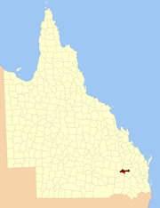
The County of Auburn is a county (a cadastral division) in the Darling Downs region of Queensland, Australia. Much of its area is within the Barakula State Forest. It was named and bounded by the Governor in Council on 7 March 1901 under the Land Act 1897.[1][2]
| Auburn Queensland | |||||||||||||||
|---|---|---|---|---|---|---|---|---|---|---|---|---|---|---|---|
 Location within Queensland | |||||||||||||||
| |||||||||||||||

Auburn is divided into parishes, as listed below:
| Parish | LGA | Coordinates |
|---|---|---|
| Athlone | Western Downs | 26°19′S 150°51′E |
| Ballon | Western Downs | 26°25′S 150°51′E |
| Bartsch | Western Downs | 26°30′S 150°07′E |
| Bembil | Western Downs | 26°14′S 150°57′E |
| Binkey | Western Downs | 26°21′S 150°11′E |
| Burraburri | Western Downs | 26°25′S 151°06′E |
| Delger | Western Downs | 26°19′S 151°03′E |
| Hookswood | Western Downs | 26°29′S 150°21′E |
| Macdonald | Western Downs | 26°21′S 150°40′E |
| Malcolm | Western Downs | 26°20′S 150°29′E |
| Pelham | Western Downs | 26°22′S 150°20′E |
| Quandong | Western Downs | 26°14′S 150°18′E |
| Wongongera | Western Downs | 26°32′S 150°31′E |
Seamless Wikipedia browsing. On steroids.
Every time you click a link to Wikipedia, Wiktionary or Wikiquote in your browser's search results, it will show the modern Wikiwand interface.
Wikiwand extension is a five stars, simple, with minimum permission required to keep your browsing private, safe and transparent.