Conistone
Village in North Yorkshire, England From Wikipedia, the free encyclopedia

Conistone is a small village in the county of North Yorkshire, England. It lies 3 miles (5 km) north of Grassington, 3 miles (5 km) south of Kettlewell and 12 miles (19 km) north of Skipton beside the River Wharfe, in Upper Wharfedale.[1]
| Conistone | |
|---|---|
 Conistone, bridge and Dib, over Wharfedale from west | |
.svg) Conistone Location within North Yorkshire | |
| OS grid reference | SD981675 |
| Civil parish | |
| Unitary authority | |
| Ceremonial county | |
| Region | |
| Country | England |
| Sovereign state | United Kingdom |
| Post town | SKIPTON |
| Postcode district | BD23 |
| Dialling code | 01756 |
| Police | North Yorkshire |
| Fire | North Yorkshire |
| Ambulance | Yorkshire |
| UK Parliament | |
History
Summarize
Perspective
Conistone is mentioned in the Domesday Book as Cunestune and belonging to Ketil.[2] The name derives from a mix of Old Danish (Kunung) and Old English (tūn), which means King's farm or Settlement.[3]
The village is set in characteristic limestone scenery, including Mossdale Caverns, the dry gorge of Conistone Dib and the limestone outcrop of Conistone Pie.[4] Above the Dib the Dales Way path connects Kettlewell, to its north, and Grassington, to its south, providing distant views over Wharfedale.[5] From the B6160 road, the Wharfe is crossed at Conistone by a stone-arch bridge,[6] which is within easy walking distance of Kilnsey, with its Crag.
The parish church, St Mary's Church, dates from the 11th or 12th century, and is a Grade II listed building.[7]
Conistone was historically in the large ancient parish of Burnsall, in Staincliffe Wapentake in the West Riding of Yorkshire.[8] It became part of the civil parish of Conistone with Kilnsey in 1866,[9] and was transferred to North Yorkshire in 1974. From 1974 to 2023 it was part of the district of Craven, it is now administered by the unitary North Yorkshire Council.
The population of the parish in the 2001 census was 117,[10] rising to 124 at the 2011 census.[11] In 2015, North Yorkshire County Council had estimated the population to be 110.[12]
Immediately to the east of the village lies Conistone Moor and Riggs Moor. The moorland here was known for its lead mines,[13] and also as being the furthest point in England from a road. Known by the Ordnance Survey as Pile of Stones, the point is on Riggs Moor and is found at 54.1427°N 1.9585°W, SE03287183.[14]
See also
Gallery
 St Mary's Church, Conistone, from the south-east
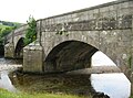 Stone arch bridge over Wharfe
 Meadowsweet along B6160, toward Kilnsey
 Wall across Dib
 View down Dib from top, at Dales Way path
 Conistone Dib


References
External links
Wikiwand - on
Seamless Wikipedia browsing. On steroids.