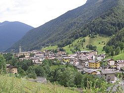
Colere
Comune in Lombardy, Italy From Wikipedia, the free encyclopedia
Colere (Bergamasque: Còler) is a comune (municipality) in the Province of Bergamo in the Italian region of Lombardy, located about 90 kilometres (56 mi) northeast of Milan and about 45 kilometres (28 mi) northeast of Bergamo. As of 31 December 2004, it had a population of 1,147 and an area of 18.8 square kilometres (7.3 sq mi).[3]
Colere | |
|---|---|
| Comune di Colere | |
 | |
| Coordinates: 45°58′N 10°5′E | |
| Country | Italy |
| Region | Lombardy |
| Province | Province of Bergamo (BG) |
| Area | |
• Total | 18.8 km2 (7.3 sq mi) |
| Elevation | 1,013 m (3,323 ft) |
| Population (Dec. 2004)[2] | |
• Total | 1,147 |
| • Density | 61/km2 (160/sq mi) |
| Demonym | Coleresi |
| Time zone | UTC+1 (CET) |
| • Summer (DST) | UTC+2 (CEST) |
| Postal code | 24020 |
| Dialing code | 0346 |
Colere borders the following municipalities: Angolo Terme, Azzone, Castione della Presolana, Rovetta, Vilminore di Scalve.
Demographic evolution

References
External links
Wikiwand - on
Seamless Wikipedia browsing. On steroids.


