Chiricahua National Monument
National monument in Arizona, U.S. From Wikipedia, the free encyclopedia
Chiricahua National Monument is a unit of the National Park System located in the Chiricahua Mountains of southeastern Arizona. The monument was established on April 18, 1924, to protect its extensive hoodoos and balancing rocks. The Faraway Ranch, which was owned at one time by Swedish immigrants Neil and Emma Erickson, is also preserved within the monument.[3]
| Chiricahua National Monument | |
|---|---|
IUCN category V (protected landscape/seascape) | |
 Rock formation on Echo Canyon Trail | |
 Location in the United States  Location in Arizona | |
| Location | Cochise County, Arizona, United States |
| Nearest city | Willcox, Arizona |
| Coordinates | 32°00′20″N 109°21′24″W |
| Area | 12,025 acres (48.66 km2)[1] |
| Created | April 18, 1924 |
| Visitors | 60,577 (in 2018)[2] |
| Governing body | National Park Service |
| Website | Chiricahua National Monument |
Just over 85% of the monument is protected as the Chiricahua National Monument Wilderness.[4]
Geology
Located approximately 36 miles (58 km) southeast of Willcox, Arizona, the monument preserves the remains of an immense volcanic eruption that shook the region about 27 million years ago. The thick, white-hot ash spewed forth from the nearby Turkey Creek Caldera, cooled and hardened into rhyolitic tuff, laying down almost 2,000 ft (610 m) of highly siliceous, dark volcanic ash and pumice. The volcanic material eventually eroded into the natural rock formations of the present monument.[5]
History
Summarize
Perspective
President Calvin Coolidge established the national monument with the Antiquities Act on April 18, 1924. It was expanded by President Franklin Roosevelt on June 10, 1938.
Missing naturalist
On January 13, 1980, Paul Fugate, a National Park Service naturalist and law enforcement ranger, disappeared after leaving the monument headquarters while in uniform, to check trails leading to the recently acquired Faraway Ranch. An acquaintance claimed to have seen him later that afternoon, slumped between two men in a pickup truck. Despite an extensive search of the rugged 17 sq mi (44 km2) monument area by authorities and search and rescue teams, no trace of him has been found.[6][7][8]
Historic Designed Landscape
Chiricahua National Monument Historic Designed Landscape | |
| Location | 12856 E. Rhyolite Canyon Rd., Chiricahua National Monument, near Willcox, Arizona |
|---|---|
| Area | approx. 10,000 acres[9] |
| Built | 1924–1940[9] |
| MPS | Historic Park Landscapes in National and State Parks MPS |
| NRHP reference No. | 08001020[10] |
| Added to NRHP | October 31, 2008[10] |
Chiricahua National Monument Historic Designed Landscape is a historic district that covers roughly 80% of the national monument. The district was listed on the National Register of Historic Places on October 31, 2008.[10][9][11]
It was the 18th property listed as a featured property of the week in a program of the National Park Service that began in July 2008.[10][12]
Proposed redesignation
In 2022, the US Senate passed S. 1320 to redesignate the monument as a national park.[13][14] The bill did not make it out of committee in the House and died with the conclusion of the 117th Congress. In early 2023, Senator Mark Kelly introduced S. 736 in the Senate, while Representative Juan Ciscomani introduced HR 1479 in the House to redesignate the Monument as a Park.[15][16] The 2023 bills passed out of committee in the Senate but have not passed out of committee in the House.
Visitor center

A visitor center is located 2 miles (3.2 km) from the entrance to Chiricahua National Monument. The visitor center has exhibits relating to the geology, natural history, and cultural history of the area. A park ranger is available to provide visitors with trail guides and information. The main road, Bonita Canyon Drive, ventures 8 mi (13 km) east through the park, ending at Massai Point. Approximately 17 mi (27 km) of trails lead hikers through various ecosystems of meadows, forests, and rock formations.
The visitor center has a free shuttle that leaves each morning at 9:00 am. The shuttle takes hikers to the Echo Canyon or Massai Point trailheads. Hikers return to the visitor center by following the designated trails.[17]
Gallery
 Big Balanced Rock along the Heart of Rocks trail
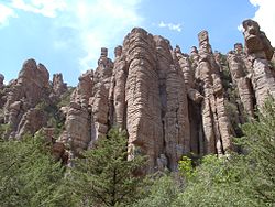 Stone columns, called hoodoos, are the most common formation in the monument
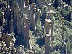 Hoodoos in Totem Canyon


Climate
Summarize
Perspective
According to the Köppen Climate Classification system, Chiricahua National Monument has a hot-summer mediterranean climate, abbreviated "Csa" on climate maps. The hottest temperature recorded at Chiricahua National Monument was 109 °F (42.8 °C) on July 13, 1909, while the coldest temperature recorded was −10 °F (−23.3 °C) on January 7, 1913.[18]
| Climate data for Chiricahua National Monument, Arizona, 1991–2020 normals, extremes 1909–2007 | |||||||||||||
|---|---|---|---|---|---|---|---|---|---|---|---|---|---|
| Month | Jan | Feb | Mar | Apr | May | Jun | Jul | Aug | Sep | Oct | Nov | Dec | Year |
| Record high °F (°C) | 80 (27) |
80 (27) |
86 (30) |
93 (34) |
104 (40) |
108 (42) |
109 (43) |
103 (39) |
100 (38) |
95 (35) |
85 (29) |
82 (28) |
109 (43) |
| Mean daily maximum °F (°C) | 56.0 (13.3) |
60.6 (15.9) |
66.5 (19.2) |
73.8 (23.2) |
82.7 (28.2) |
91.4 (33.0) |
90.2 (32.3) |
86.7 (30.4) |
83.8 (28.8) |
76.4 (24.7) |
66.4 (19.1) |
55.7 (13.2) |
74.2 (23.4) |
| Daily mean °F (°C) | 43.1 (6.2) |
46.6 (8.1) |
51.5 (10.8) |
57.2 (14.0) |
65.7 (18.7) |
74.2 (23.4) |
75.1 (23.9) |
73.4 (23.0) |
70.2 (21.2) |
61.8 (16.6) |
52.0 (11.1) |
43.1 (6.2) |
59.5 (15.3) |
| Mean daily minimum °F (°C) | 30.3 (−0.9) |
32.6 (0.3) |
36.5 (2.5) |
40.5 (4.7) |
48.8 (9.3) |
57.0 (13.9) |
60.0 (15.6) |
60.0 (15.6) |
56.6 (13.7) |
47.2 (8.4) |
37.5 (3.1) |
30.5 (−0.8) |
44.8 (7.1) |
| Record low °F (°C) | −10 (−23) |
7 (−14) |
10 (−12) |
20 (−7) |
19 (−7) |
35 (2) |
40 (4) |
44 (7) |
33 (1) |
21 (−6) |
8 (−13) |
−1 (−18) |
−10 (−23) |
| Average precipitation inches (mm) | 1.32 (34) |
1.28 (33) |
1.19 (30) |
0.27 (6.9) |
0.30 (7.6) |
0.86 (22) |
3.81 (97) |
4.56 (116) |
1.59 (40) |
0.99 (25) |
1.04 (26) |
1.50 (38) |
18.71 (475.5) |
| Average snowfall inches (cm) | 1.3 (3.3) |
0.5 (1.3) |
0.2 (0.51) |
0.0 (0.0) |
0.0 (0.0) |
0.0 (0.0) |
0.0 (0.0) |
0.0 (0.0) |
0.0 (0.0) |
0.1 (0.25) |
0.4 (1.0) |
1.2 (3.0) |
3.7 (9.36) |
| Average precipitation days (≥ 0.01 in) | 5.4 | 5.4 | 4.6 | 2.0 | 2.2 | 3.5 | 13.1 | 12.6 | 6.3 | 4.2 | 4.0 | 5.5 | 68.8 |
| Average snowy days (≥ 0.1 in) | 0.5 | 0.5 | 0.1 | 0.0 | 0.0 | 0.0 | 0.0 | 0.0 | 0.0 | 0.1 | 0.2 | 0.4 | 1.8 |
| Source 1: NOAA[19] | |||||||||||||
| Source 2: National Weather Service[18] | |||||||||||||
See also
References
External links
Wikiwand - on
Seamless Wikipedia browsing. On steroids.