Chavanon
River in France From Wikipedia, the free encyclopedia
The Chavanon (French pronunciation: [ʃavanɔ̃]; Occitan: Chavanon) (also called la Ramade) is a 54.2-kilometre (33.7 mi) long river in the Creuse, Puy-de-Dôme, and Corrèze départements, central France.[1] Its source is in Crocq. It flows generally southeast. It is a right tributary of the Dordogne into which it flows between Savennes and Confolent-Port-Dieu.
| Chavanon | |
|---|---|
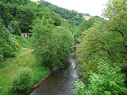
 The Chavanon between Feyt and Bourg-Lastic | |
| Location | |
| Country | France |
| Physical characteristics | |
| Source | |
| • location | Crocq |
| • coordinates | 45°50′26″N 02°22′40″E |
| • elevation | 780 m (2,560 ft) |
| Mouth | |
• location | Dordogne |
• coordinates | 45°33′14″N 02°30′57″E |
• elevation | 530 m (1,740 ft) |
| Length | 54.2 km (33.7 mi) |
| Basin size | 474 km2 (183 sq mi) |
| Discharge | |
| • average | 6.53 m3/s (231 cu ft/s) |
| Basin features | |
| Progression | Dordogne→ Gironde estuary→ Atlantic Ocean |
For most of its course, it forms part of the boundary between the Limousin and Auvergne regions.
Départements and communes along its course
This list is ordered from source to mouth:
- Creuse: Crocq, Basville, Flayat
- Puy-de-Dôme: Fernoël, Giat,
- Creuse: Saint-Merd-la-Breuille,
- Puy-de-Dôme: Verneugheol,
- Corrèze: Laroche-près-Feyt,
- Puy-de-Dôme: Saint-Germain-près-Herment, Bourg-Lastic,
- Corrèze: Feyt, Monestier-Merlines,
- Puy-de-Dôme: Messeix,
- Corrèze: Merlines,
- Puy-de-Dôme: Savennes,
- Corrèze: Saint-Étienne-aux-Clos, Confolent-Port-Dieu,
References
Wikiwand - on
Seamless Wikipedia browsing. On steroids.


