Channarayapatna
Town in Karnataka, India From Wikipedia, the free encyclopedia

Channarayapatna is a town and Taluk headquarters in Hassan district of Karnataka, India. It lies on the Bangalore-Mangalore National Highway-75 in Karnataka, India. Jain pilgrimage Shravanabelagola is a famous site in the taluk. Channarayapatna has major railway connection from Bangalore to Mangalore, Karwar, and Mysore.
Channarayapatna | |
|---|---|
Town | |
 | |
 Channarayapatna Location in Karnataka, India | |
| Coordinates: 12.902°N 76.364°E | |
| Country | |
| State | Karnataka |
| District | Hassan |
| Government | |
| • Body | Town Municipal Council |
| Area | |
| • Town | 10.50 km2 (4.05 sq mi) |
| • Rural | 1,063.86 km2 (410.76 sq mi) |
| Elevation | 827 m (2,713 ft) |
| Population (2011)[1] | |
| • Town | 40,417 |
| • Rank | 3rd in Hassan district |
| • Density | 3,800/km2 (10,000/sq mi) |
| • Rural | 241,006 |
| Languages | |
| • Official | Kannada |
| Time zone | UTC+5:30 (Indian Standard Time) |
| Postal Index Number (PIN) | 573116, 573225 |
| Telephone code | 08176 |
| Vehicle registration | KA-13 |
| Website | www |
Geography
Channarayapatna is located at 12.90°N 76.39°E.[2] It has an average elevation of 845 metres (2716 ft).
Located within Channarayapatna is Bagur Navile Tunnel, the longest water tunnel in India.
Demographics
As of 2011 India census, Channarayapatna has a population of 279,798. Males constitute 51% of the population and females 49%. Channarayapatna has an average literacy rate of 73%, higher than the national average of 59.5%; with male literacy of 78% and female literacy of 68%. 11% of the population is under 6 years of age.[3]
Administration
Taluk
Channarayapatna Taluk is one of the eight taluks in Hassan district of Karnataka state. There are 40 panchayat villages in Channarayapatna Taluk,[4][5] for 407 villages.[6]
Economy
Agriculture is the major economic activity. Sugarcane & Coconut are the leading commercial crops, while food crops include Ragi, Potato, Sunflower, and Paddy.[7] The taluk also has mineral reserves, such as chromite.[7]
Gallery
 Map of Channarayapatna Taluk as per 2001 Census
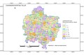 Map of Channarayapatna Taluk as per 2001 Census
 Positioning of Hassan district in Karnataka
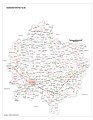 Village Map of Channarayapatna Taluk
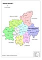 Hobli Map of Hassan district
 Hobli & Village Map of Shravanabelagola Assembly constituency, Channarayapatna Taluk
 Village Map of Shravanabelagola Assembly constituency, Channarayapatna Taluk
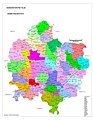 Grama panchayat and Village Map of Channarayapatna Taluk
 Tourism Map of Channarayapatna Taluk
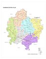 Channarayapatna Taluk - Hobli and Village Map
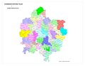 Channarayapatna Taluk - Grama Panchayat and Village Map
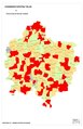
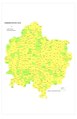 Channarayapatna Taluk Map about Fluoride content in DWS


Notable people
- H. C. Srikantaiah, Former Minister and Member of Parliament
- S. L. Bhyrappa, novelist and professor
- Nanditha, playback singer
- C. N. Manjunath, cardiologist
- C N Balakrishna, MLA Sravanabelogaola Constituency
- C.Aswath, Singer
See also
References
External links
Wikiwand in your browser!
Seamless Wikipedia browsing. On steroids.
Every time you click a link to Wikipedia, Wiktionary or Wikiquote in your browser's search results, it will show the modern Wikiwand interface.
Wikiwand extension is a five stars, simple, with minimum permission required to keep your browsing private, safe and transparent.