Changyang Tujia Autonomous County
County in Hubei, People's Republic of China From Wikipedia, the free encyclopedia
Changyang Tujia Autonomous County (simplified Chinese: 长阳土家族自治县; traditional Chinese: 長陽土家族自治縣; pinyin: Chángyáng Tǔjiāzú Zìzhìxiàn) or in Tujia language known as Changryangf Bifzivkar Zivzirxianf is an autonomous county in western Hubei province, People's Republic of China. It is under the administration of the prefecture-level city of Yichang.
Changyang County
长阳县 | |
|---|---|
| 长阳土家族自治县 Changyang Tujia Autonomous County | |
 Longzhou Boulevard | |
 Changyang Location in Hubei | |
| Coordinates: 30°28′N 110°52′E | |
| Country | People's Republic of China |
| Province | Hubei |
| Prefecture-level city | Yichang |
| Area | |
• Total | 3,430 km2 (1,320 sq mi) |
| Population (2020)[1] | |
• Total | 305,740 |
| • Density | 89/km2 (230/sq mi) |
| Time zone | UTC+8 (China Standard) |
| Website | changyang |
The county is located in the basin of the Qing River, a right tributary of the Yangtze. The river is flanked by mountains on both sides, the tallest of which - the Tianzhu Mountain - is 2,542 metres (8,340 ft) tall. The river is dammed by the Geheyan Dam (located within the county) and the Gaoba Dam (located in the neighboring Yidu County-level City, but flooding some of the Qingjiang River valley within Changyang County as well). The resulting reservoirs provide the main water transportation route throughout much of the county.
Established in 1984 with a surface area of 3,412 square kilometres (1,317 sq mi) and a population in 1984 of 399,000 inhabitants, of which 295,000 were Tujia.[2]
Administrative divisions
- Longzhouping (龙舟坪镇), Gaojiayan (高家堰镇), Moshi (磨市镇), Duzhenwan (都镇湾镇), Ziqiu (资丘镇), Yuxiakou (渔峡口镇), Langping (榔坪镇), Hejiaping (贺家坪镇)
Three townships:
Climate
| Climate data for Changyang, elevation 178 m (584 ft), (1991–2020 normals, extremes 1981–present) | |||||||||||||
|---|---|---|---|---|---|---|---|---|---|---|---|---|---|
| Month | Jan | Feb | Mar | Apr | May | Jun | Jul | Aug | Sep | Oct | Nov | Dec | Year |
| Record high °C (°F) | 22.9 (73.2) |
29.0 (84.2) |
35.1 (95.2) |
37.9 (100.2) |
39.8 (103.6) |
40.1 (104.2) |
40.8 (105.4) |
41.1 (106.0) |
39.9 (103.8) |
35.0 (95.0) |
28.8 (83.8) |
25.1 (77.2) |
41.1 (106.0) |
| Mean daily maximum °C (°F) | 8.8 (47.8) |
11.6 (52.9) |
16.7 (62.1) |
22.9 (73.2) |
26.9 (80.4) |
30.0 (86.0) |
32.5 (90.5) |
32.2 (90.0) |
27.9 (82.2) |
22.6 (72.7) |
16.8 (62.2) |
11.3 (52.3) |
21.7 (71.0) |
| Daily mean °C (°F) | 5.0 (41.0) |
7.3 (45.1) |
11.6 (52.9) |
17.1 (62.8) |
21.4 (70.5) |
24.9 (76.8) |
27.4 (81.3) |
26.9 (80.4) |
22.8 (73.0) |
17.6 (63.7) |
12.2 (54.0) |
7.1 (44.8) |
16.8 (62.2) |
| Mean daily minimum °C (°F) | 2.2 (36.0) |
4.2 (39.6) |
7.9 (46.2) |
13.0 (55.4) |
17.4 (63.3) |
21.3 (70.3) |
23.8 (74.8) |
23.4 (74.1) |
19.5 (67.1) |
14.4 (57.9) |
9.2 (48.6) |
4.2 (39.6) |
13.4 (56.1) |
| Record low °C (°F) | −4.9 (23.2) |
−3.5 (25.7) |
−1.3 (29.7) |
2.3 (36.1) |
9.3 (48.7) |
12.7 (54.9) |
17.0 (62.6) |
15.8 (60.4) |
12.1 (53.8) |
3.4 (38.1) |
−1.2 (29.8) |
−4.1 (24.6) |
−4.9 (23.2) |
| Average precipitation mm (inches) | 34.9 (1.37) |
44.0 (1.73) |
69.0 (2.72) |
120.9 (4.76) |
164.3 (6.47) |
182.1 (7.17) |
250.5 (9.86) |
191.1 (7.52) |
105.0 (4.13) |
88.6 (3.49) |
56.0 (2.20) |
22.0 (0.87) |
1,328.4 (52.29) |
| Average precipitation days (≥ 0.1 mm) | 8.8 | 9.8 | 12.5 | 13.5 | 14.6 | 14.3 | 15.5 | 13.9 | 11.4 | 11.3 | 9.9 | 8.0 | 143.5 |
| Average snowy days | 4.0 | 2.9 | 1.0 | 0 | 0 | 0 | 0 | 0 | 0 | 0 | 0.3 | 1.0 | 9.2 |
| Average relative humidity (%) | 77 | 77 | 77 | 78 | 79 | 82 | 83 | 82 | 80 | 80 | 81 | 77 | 79 |
| Mean monthly sunshine hours | 68.6 | 73.5 | 107.2 | 130.5 | 136.2 | 132.7 | 166.7 | 171.1 | 121.2 | 110.9 | 95.2 | 82.9 | 1,396.7 |
| Percentage possible sunshine | 21 | 23 | 29 | 34 | 32 | 31 | 39 | 42 | 33 | 32 | 30 | 26 | 31 |
| Source: China Meteorological Administration[5][6] | |||||||||||||
Transportation
The new Yichang-Wanzhou Railway crosses the northwestern part of the county, with two stations - Langping and Hejiaping - located near the eponymous towns of the county.
The China National Highway 318, and the newly constructed Shanghai-Chongqing Expressway (G50) run roughly parallel to the railway. Building the expressway in this area required the construction of a number of tunnels and remarkable bridges, such as the Longtanhe Bridge just outside Langping Town.[7]
 Changyang Square
 Old street
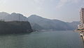 Qing River
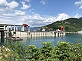 Geheyan Dam
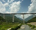 Longtanhe Bridge
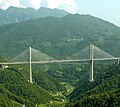 Tieluoping bridge, west of Langping town


References
Wikiwand - on
Seamless Wikipedia browsing. On steroids.