Loading AI tools
Cavendish is a local service district and designated place in the Canadian province of Newfoundland and Labrador.
This article needs additional citations for verification. (September 2014) |
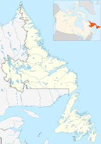
Location of Cavendish in Newfoundland and Labrador
Cavendish is in Newfoundland within Subdivision E of Division No. 1.[1] Cavendish is located on Route 80, off the Route 1 (Trans Canada Highway) exit at Whitbourne. It lies on an area of Cambrian Period shale, slate, and limestone; a significant limestone prospect lies about one kilometre (0.62 mi) south of the settlement.[2] Soils are mapped as stony loam podzols of the Cochrane and Turk's Cove series.[3]
As a designated place in the 2016 Census of Population conducted by Statistics Canada, Cavendish recorded a population of 301 living in 120 of its 138 total private dwellings, a change of -17.1% from its 2011 population of 363. With a land area of 2.69 km2 (1.04 sq mi), it had a population density of 111.9/km2 (289.8/sq mi) in 2016.[4]
Cavendish is a local service district (LSD)[5] that is governed by a committee responsible for the provision of certain services to the community.[6] The chair of the LSD committee is Roger Pennell.[5]
Wikiwand in your browser!
Seamless Wikipedia browsing. On steroids.
Every time you click a link to Wikipedia, Wiktionary or Wikiquote in your browser's search results, it will show the modern Wikiwand interface.
Wikiwand extension is a five stars, simple, with minimum permission required to keep your browsing private, safe and transparent.
