Borzinsky District
District in Zabaykalsky Krai, Russia From Wikipedia, the free encyclopedia
District in Zabaykalsky Krai, Russia From Wikipedia, the free encyclopedia
Seamless Wikipedia browsing. On steroids.
Every time you click a link to Wikipedia, Wiktionary or Wikiquote in your browser's search results, it will show the modern Wikiwand interface.
Wikiwand extension is a five stars, simple, with minimum permission required to keep your browsing private, safe and transparent.
Borzinsky District (Russian: Борзинский район) is an administrative[1] and municipal[6] district (raion), one of the thirty-one in Zabaykalsky Krai, Russia. It is located in the south of the krai, and borders with Olovyanninsky District in the north, Aleksandrovo-Zavodsky District in the east, Zabaykalsky District in the south, and with Ononsky District in the west. The area of the district is 9,000 square kilometers (3,500 sq mi).[2] Its administrative center is the town of Borzya.[1] Population: 51,647 (2010 Census);[3] 25,095 (2002 Census);[9] 30,885 (1989 Soviet census).[10] The population of Borzya accounts for 60.8% of the district's total population.[3]
Borzinsky District
Борзинский район | |
|---|---|
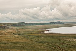
 Torey Lakes | |
 Location of Borzinsky District in Zabaykalsky Krai | |
| Coordinates: 50.491°N 116.864°E | |
| Country | Russia |
| Federal subject | Zabaykalsky Krai[1] |
| Established | January 4, 1926[1] |
| Administrative center | Borzya[1] |
| Area | |
| • Total | 9,000 km2 (3,000 sq mi) |
| Population | |
| • Total | 51,647 |
| • Estimate (2018)[4] | 47,409 (−8.2%) |
| • Density | 5.7/km2 (15/sq mi) |
| • Urban | 84.9% |
| • Rural | 15.1% |
| Administrative structure | |
| • Inhabited localities[1] | 1 cities/towns, 1 Urban-type settlements[5], 19 rural localities |
| Municipal structure | |
| • Municipally incorporated as | Borzinsky Municipal District[6] |
| • Municipal divisions[7] | 2 urban settlements, 15 rural settlements |
| Time zone | UTC+9 (MSK+6 |
| OKTMO ID | 76609000 |
| Website | http://www.admin-borzya.ru/ |
The district was established on January 4, 1926.[1]