Borders of Venezuela
From Wikipedia, the free encyclopedia
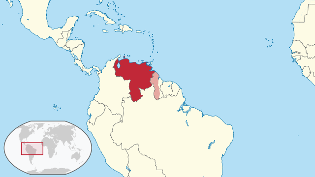
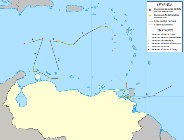
The borders of Venezuela are the international borders that Venezuela shares with neighboring countries. Venezuela borders with 14 countries totaling 5,161 kilometers which includes territories of France (Martinique and Guadeloupe), the Kingdom of the Netherlands (Aruba, Curaçao and Bonaire), the United Kingdom (Montserrat) and the United States (Puerto Rico and the United States Virgin Islands). Venezuela has the seventh largest number of land and maritime borders after France, China, the United Kingdom, Russia, the United States and Italy.


Bordering countries
The lengths of the borders Venezuela shares with different countries, running counter-clockwise around Grenada to Caribbean Netherlands, are listed below:
| Country | Length (km) | Bordering Venezuelan states | Border features | Border crossings |
|---|---|---|---|---|
| 160 | Sucre | N/A | N/A | |
| 11 | Sucre Delta Amacuro |
Gulf of Paria Bocas del Dragón |
Güiria | |
| 743 | Delta Amacuro Bolívar |
Mount Roraima | N/A | |
| 2,200 | Bolívar Amazonas |
Mount Roraima | Santa Elena de Uairen | |
| 2,219 | Amazonas Apure Táchira Zulia Falcón |
Táchira River Gulf of Venezuela Guajira Peninsula |
Puerto Ayacucho San Fernando de Atabapo Simón Bolívar International Bridge Ureña | |
→includes: → → → |
65−80 | Falcón | ABC islands | N/A |
Total list
Summarize
Perspective
This is a list of countries and territories by land and maritime borders bordering Venezuela. The number and identity of other countries and territories that neighbor it are listed. Land borders and maritime boundaries are included and are tabulated separately and in combination. For purposes of this list, "maritime boundary" includes boundaries that are recognized by the United Nations Convention on the Law of the Sea, which includes boundaries of territorial waters, contiguous zones, and exclusive economic zones. However, it does not include lake or river boundaries, which are considered land boundaries.
Also included is the number of unique sovereign states[1] that a country or territory shares as neighbors. If the number is higher due to multiple dependencies or unrecognized states bordering the state, the larger number is shown in brackets.
Footnotes are provided to provide clarity regarding the status of certain countries and territories.
| Country or territory (Territories without full sovereignty[1] in italics) |
No. of land border neighbors[2] | No. of maritime boundary neighbors[2] | Total no. of unique neighbors[2] | Neighboring countries and territories (Territories without full sovereignty[1] in italics) (L) = share only land borders (M) = share only maritime boundaries blank = share land borders and maritime boundaries |
|---|---|---|---|---|
| 3 | 14 (17) | 15 (18) | ||
Border disputes

With Guyana
Gallery
- Flags of Brazil and Venezuela on the Brazil-Venezuela border in Pacaraima, Brazil.
- Simón Bolívar International Bridge in Cúcuta, Colombia.
- Tripoint between Brazil, Venezuela and Guyana located on Mount Roraima. Due to the Guyana–Venezuela territorial dispute, Venezuela does not recognize this point as the tripoint.
See also
References
Wikiwand - on
Seamless Wikipedia browsing. On steroids.


