Boundaries of Hong Kong
Regulated administrative border From Wikipedia, the free encyclopedia

The Boundaries of Hong Kong, officially the Boundary of the Administrative Division of the Hong Kong Special Administrative Region of the People's Republic of China[1][2] (Chinese: 中華人民共和國香港特別行政區行政區域界綫), is a regulated administrative border with border control in force under the One country, two systems constitutional principle, which separates the Hong Kong Special Administrative Region from mainland China, by land border fence of 30 km (19 mi) and maritime boundary of 733 km (455 mi),[1] enforcing a separate immigration and customs-controlled jurisdiction from mainland China.
The boundaries of Hong Kong are patrolled and controlled by the Hong Kong Police Force and its Marine Region and the Immigration Department at land and sea. The land boundary also includes a buffer zone, known as Frontier Closed Area.

History
Summarize
Perspective
This section needs expansion with: more detailed timeline and additional citations. You can help by adding to it. (June 2021) |
After the First Opium War and territorial establishment of Hong Kong, the Hong Kong Island was ceded by the Qing Empire to the United Kingdom of Great Britain and Ireland through Treaty of Nanjing in 1842, not marking any official maritime boundaries.
In 1860, the Convention of Peking extended the cession to include Kowloon with the land boundary limits until "Boundary street in Kowloon",[3] and in 1898 with additional land of New Territories was leased for 99-years to the British under the Convention for the Extension of Hong Kong Territory with the Sham Chun River primarily marking the boundary between British Hong Kong and Qing dynasty.[4]
Between the years of 1941 and 1945 during the Japanese occupation of Hong Kong, the boundaries of Hong Kong may or may not have been clearly distinguished as the neighbouring part of Southern China bordering Hong Kong was also occupied by the Japanese Empire.[5] After the Japanese surrender in 1945, all British government institutions in Hong Kong, including the land boundary primarily running across the Sham Chun River were restored.[6]
Since the late 1940s, there has been a refugee wave from mainland China due to the instability inland, and the British authorities in Hong Kong were forced to make a decision regarding the border to prevent an influx of refugees from overwhelming the already-crowded city. In April 1949, the British decided to close the border and end the free movement that existed prior.[7] By 1952, the Chinese authorities had done the same, and the border officially became closed and required permits to cross through.[8]
In 1984, the governments of the United Kingdom and the People's Republic of China (PRC) concluded the Sino-British Joint Declaration on the Question of Hong Kong, under which the sovereignty of the leased territories, together with Hong Kong Island and Kowloon (south of Boundary Street) ceded under the Convention of Peking (1860), was transferred to the PRC on 1 July 1997, maintaining the current land boundary primarily running across the Sham Chun River,[9] however the Hong Kong Basic Law modified and extended the size of Hong Kong's maritime boundary with mainland China in 1997.[1]
Historical maps
 One of the earliest documents, marking the boundaries of the then British Hong Kong with Qing dynasty.
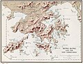 Map of the boundaries of Hong Kong during the Colonial period until 1997.


Immigration control points
Summarize
Perspective
As of 2024, 8 out of Hong Kong's 13 points of entry or border crossings controlled by the Immigration Department are located on or cross the land border fence.[10] Entry and exit immigration clearance into Hong Kong by sea can be cleared at 3 ferry terminals:,[10] and the other 2 out of 13 immigration clearance points in Hong Kong are located in the Hong Kong West Kowloon railway station and at the Hong Kong International Airport.[10]

See also
References
Wikiwand - on
Seamless Wikipedia browsing. On steroids.