Top Qs
Timeline
Chat
Perspective
Boissei-la-Lande
Commune in Normandy, France From Wikipedia, the free encyclopedia

Remove ads
Boissei-la-Lande (French pronunciation: [bwasɛ la lɑ̃d] ⓘ) is a commune in the Orne department in northwestern France.


Remove ads
Geography
The commune is made up of the following collection of villages and hamlets, Le Friche du Val,Thion, Le Theil, La Rivière,Pillou,La Hauteville and Boissei-la-Lande.[3]
Boissei-la-Lande along with another 65 communes is part of a 20,593 hectare, Natura 2000 conservation area, called the Haute vallée de l'Orne et affluents.[4]
In addition to the Orne river, the commune also has three streams running through it, the Calvaire, L'Epinet and La Gironde.[5]
Remove ads
Population
Notable buildings and places
National heritage sites
The Commune has 2 buildings and areas listed as a Monument historique.
- Church Farm a 16th century farmhouse listed as a monument in 1986.[7]
- Church of Boissei-la-Lande a 16th century church listed as a monument in 1986.[8]
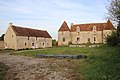 Boissei-la-Lande - Church farm
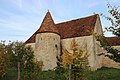 Boissei-la-Lande church farm
 Boissei-la-Lande church


See also
References
Wikiwand - on
Seamless Wikipedia browsing. On steroids.
Remove ads