Boca Chica Key
Island in the lower Florida Keys From Wikipedia, the free encyclopedia
Boca Chica Key is an island in the lower Florida Keys, about a mile (1.6 km) east of the island of Key West at its closest point. Its name is Spanish for "small mouth". It is mostly covered by salt marshes and mangrove trees, and is the home of the largest Naval Air Station (NAS Key West) in south Florida. U.S. 1, the Overseas Highway, crosses the key at approximately mile markers 6.5—8, east of Key West.,[1] near the NAS and Boca Chica Beach (aka Geiger Beach) on Boca Chica Road.[2][3]

 Boca Chica Key Boca Chica Key  Boca Chica Key Boca Chica Key (Caribbean) | |
| Geography | |
|---|---|
| Location | Gulf of Mexico |
| Coordinates | 24.5774°N 81.6933°W |
| Archipelago | Florida Keys |
| Adjacent to | Florida Straits |
| Administration | |
| State | Florida |
| County | Monroe |
Gallery
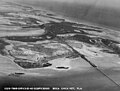 Boca Chica Key, April 1940
 Boca Chica Key, April 1940
.jpg)
.jpg)
References
Wikiwand - on
Seamless Wikipedia browsing. On steroids.