Top Qs
Timeline
Chat
Perspective
Bexley, New South Wales
Suburb of Sydney, New South Wales, Australia From Wikipedia, the free encyclopedia

Remove ads
Bexley is a suburb in southern Sydney, in the state of New South Wales, Australia. Bexley is located 14 kilometres (8.7 mi) south-west of the Sydney central business district, in the local government area of the Bayside Council and is part of the St George area.

Remove ads
Commercial area


Transport
Bexley is currently served by Transit Systems and U-Go Mobility bus services. A steam tramway opened on 13 October 1909 and operated from Arncliffe railway station via Firth and Done Streets and then onto Wollongong, Forest and Stoney Creek Roads to Bexley Park, near Preddys Road. It closed on 1 January 1927.[2]
Population


According to the 2021 census of Population, there were 19,646 people usually resident in Bexley. 52.7% of people were born in Australia. The next most common countries of birth were China 6.7%, Lebanon 5.3%, Macedonia 3.8%, Greece 2.9% and Philippines 1.8%. 38.2% of people only spoke English at home. Other languages spoken at home included Arabic 13.2%, Greek 7.1%, Macedonian 6.3%, Mandarin 6.0% and Cantonese 5.1%. The most common responses were Catholic 20.9%, No Religion 19.9%, Islam 16.3% and Eastern Orthodox 16.1%.[1]
Notable residents
- Patricia Carlon - crime fiction/thriller writer[3]
- Richard White - tech billionaire[4]
Gallery
Houses
 Two-storey home, Gladstone Street
 Single-storey Federation cottage with wrought-iron detailing, Gladstone Street
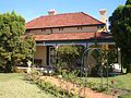 Cottage with wrap-around verandahs and wrought-iron detailing, Harrow Road
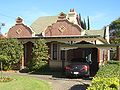 Esperanza, Harrow Road


References
Wikiwand - on
Seamless Wikipedia browsing. On steroids.
Remove ads