Top Qs
Timeline
Chat
Perspective
Bernkastel-Wittlich
District in Rhineland-Palatinate, Germany From Wikipedia, the free encyclopedia
Remove ads
Bernkastel-Wittlich (German: Landkreis Bernkastel-Wittlich) is a district in Rhineland-Palatinate, Germany. It is bounded by (from the north and clockwise) the districts of Vulkaneifel, Cochem-Zell, Rhein-Hunsrück, Birkenfeld, Trier-Saarburg and Bitburg-Prüm.
This article needs additional citations for verification. (March 2013) |
Remove ads
History
The district was established in 1969 by merging the former districts of Bernkastel and Wittlich.
Geography
The district is situated on both banks of the Moselle, which crosses the territory from southwest to northeast. The country rises to the Eifel in the north and the Hunsrück in the south. A great number of tributaries rise in the Eifel and flow into the Moselle. In the very south of the district is the Erbeskopf (818 m), the highest peak in the Hunsrück and Rhineland-Palatinate.
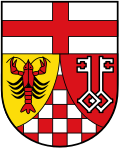
Coat of arms
The coat of arms displays:
- The cross symbolising the bishopric of Trier
- The crayfish from the arms of Bernkastel-Kues
- The keys from the arms of Wittlich
- The red and white pattern of the County of Sponheim, which ruled this part of the Moselle valley in medieval times
Towns and municipalities
Remove ads
Twin region
At one time, the Borough of Milton Keynes was the twinned region of the district of Bernkastel-Wittlich[ 1 ].
External links
- Official website (German)
References
Wikiwand - on
Seamless Wikipedia browsing. On steroids.
Remove ads


