Balete, Batangas
Municipality in Batangas, Philippines From Wikipedia, the free encyclopedia

Balete, officially the Municipality of Balete (Tagalog: Bayan ng Balete), is a municipality in the province of Batangas, Philippines. According to the 2020 census, it has a population of 24,055 people.[3] The people from Balete is called Baleteños.
Balete | |
|---|---|
| Municipality of Balete | |
 Street in Balete | |
 Flag  Seal | |
| Nickname(s): Land of Honeybees, Biking Capital of CALABARZON | |
 Map of Batangas with Balete highlighted | |
OpenStreetMap  | |
.svg) Balete Location within the Philippines | |
| Coordinates: 14°01′N 121°06′E | |
| Country | Philippines |
| Region | Calabarzon |
| Province | Batangas |
| District | 3rd district |
| Founded | June 21, 1969 |
| Barangays | 13 (see Barangays) |
| Government | |
| • Type | Sangguniang Bayan |
| • Mayor | Wilson V. Maralit |
| • Vice Mayor | Alvin T. Payo |
| • Representative | Ma. Theresa V. Collantes |
| • Municipal Council | Members |
| • Electorate | 15,206 voters (2025) |
| Area | |
• Total | 25.00 km2 (9.65 sq mi) |
| Elevation | 187 m (614 ft) |
| Highest elevation | 383 m (1,257 ft) |
| Lowest elevation | 5 m (16 ft) |
| Population (2020 census)[3] | |
• Total | 24,055 |
| • Density | 960/km2 (2,500/sq mi) |
| • Households | 5,709 |
| Economy | |
| • Income class | 5th municipal income class |
| • Poverty incidence | 7.69 |
| • Revenue | ₱ 134.1 million (2022) |
| • Assets | ₱ 367.3 million (2022) |
| • Expenditure | ₱ 114.8 million (2022) |
| • Liabilities | ₱ 191.4 million (2022) |
| Service provider | |
| • Electricity | Batangas 2 Electric Cooperative (BATELEC 2) |
| Time zone | UTC+8 (PST) |
| ZIP code | 4219 |
| PSGC | |
| IDD : area code | +63 (0)43 |
| Native languages | Tagalog |
Balete is well known for its location on Taal Lake, providing a panoramic view of the Taal Volcano. The pilgrimage site Marian Orchard is located in Barangay Malabanan. The town's name originates from the tree of the same name that grew abundantly in the area.[5]
History
Balete was once a barrio that was a part of Lipa. It was the site of Lipa's third municipal center from circa 1702 to 1754. Due to a Taal Volcano eruption, Lipa moved its center to its present location inland to seek refuge from further volcanic eruptions.[6]
On June 21, 1969, barrios Malabanan, Looc, Alangilan, Palsara, Makina, Magapi, Solis, Sampalukan, Calawit, and Balete and the sitios of Sala, Paligawan, and Wani-Wani were separated from Lipa and constituted into a new independent municipality of Balete.[7]
Geography
Summarize
Perspective
According to the Philippine Statistics Authority, the municipality has a land area of 25.00 square kilometers (9.65 sq mi) [8] constituting 0.80% of the 3,119.75-square-kilometer (1,204.54 sq mi) total area of Batangas.
Barangays
Balete is politically subdivided into 13 barangays, as indicated in the matrix below.[9] Each barangay consists of puroks and some have sitios.
| PSGC | Barangay | Population | ±% p.a. | |||
|---|---|---|---|---|---|---|
| 2020[3] | 2010[10] | |||||
| 041004001 | Alangilan | 5.9% | 1,428 | 1,296 | 0.97% | |
| 041004002 | Calawit | 4.3% | 1,028 | 809 | 2.42% | |
| 041004003 | Looc | 8.7% | 2,098 | 2,005 | 0.45% | |
| 041004004 | Magapi | 8.9% | 2,133 | 1,947 | 0.92% | |
| 041004005 | Makina | 7.3% | 1,757 | 1,519 | 1.47% | |
| 041004006 | Malabanan | 19.3% | 4,637 | 4,119 | 1.19% | |
| 041004007 | Paligawan | 8.5% | 2,047 | 1,802 | 1.28% | |
| 041004008 | Palsara | 5.8% | 1,391 | 1,381 | 0.07% | |
| 041004009 | Poblacion | 10.7% | 2,573 | 2,405 | 0.68% | |
| 041004010 | Sala | 7.3% | 1,753 | 1,429 | 2.06% | |
| 041004011 | Sampalocan | 4.5% | 1,086 | 1,003 | 0.80% | |
| 041004012 | Solis | 7.1% | 1,712 | 1,634 | 0.47% | |
| 041004013 | San Sebastian | 4.2% | 1,018 | 1,865 | −5.87% | |
| Total | 24,055 | 20,214 | 1.75% | |||
Climate
| Climate data for Balete, Batangas | |||||||||||||
|---|---|---|---|---|---|---|---|---|---|---|---|---|---|
| Month | Jan | Feb | Mar | Apr | May | Jun | Jul | Aug | Sep | Oct | Nov | Dec | Year |
| Mean daily maximum °C (°F) | 29 (84) |
30 (86) |
31 (88) |
33 (91) |
32 (90) |
30 (86) |
29 (84) |
29 (84) |
29 (84) |
29 (84) |
29 (84) |
29 (84) |
30 (86) |
| Mean daily minimum °C (°F) | 20 (68) |
20 (68) |
21 (70) |
22 (72) |
24 (75) |
24 (75) |
24 (75) |
24 (75) |
24 (75) |
23 (73) |
22 (72) |
21 (70) |
22 (72) |
| Average precipitation mm (inches) | 11 (0.4) |
13 (0.5) |
14 (0.6) |
32 (1.3) |
101 (4.0) |
142 (5.6) |
208 (8.2) |
187 (7.4) |
175 (6.9) |
131 (5.2) |
68 (2.7) |
39 (1.5) |
1,121 (44.3) |
| Average rainy days | 5.2 | 5.0 | 7.4 | 11.5 | 19.8 | 23.5 | 27.0 | 25.9 | 25.2 | 23.2 | 15.5 | 8.3 | 197.5 |
| Source: Meteoblue[11] (Use with caution: this is modeled/calculated data, not measured locally.) | |||||||||||||
Demographics
| Year | Pop. | ±% p.a. |
|---|---|---|
| 1970 | 7,134 | — |
| 1975 | 8,229 | +2.91% |
| 1980 | 8,698 | +1.11% |
| 1990 | 11,678 | +2.99% |
| 1995 | 14,383 | +3.98% |
| 2000 | 15,792 | +2.02% |
| 2007 | 19,252 | +2.77% |
| 2010 | 20,214 | +1.79% |
| 2015 | 22,661 | +2.20% |
| 2020 | 24,055 | +1.18% |
| Source: Philippine Statistics Authority[12][10][13][14] | ||
In the 2020 census, Balete had a population of 24,055.[3] The population density was 960 inhabitants per square kilometer (2,500/sq mi).
Economy
Poverty incidence of Balete
10
20
30
40
50
60
2000
50.61 2003
31.99 2006
24.60 2009
17.20 2012
10.59 2015
7.72 2018
12.66 2021
7.69 Source: Philippine Statistics Authority[15][16][17][18][19][20][21][22] |
Gallery
 Municipal hall
 Police station
 Municipal park
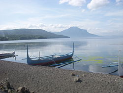 Fishing boats on the shore of Taal Lake
 Marian Orchard


References
External links
Wikiwand - on
Seamless Wikipedia browsing. On steroids.