Top Qs
Timeline
Chat
Perspective
Baicheng County
County in Xinjiang, China From Wikipedia, the free encyclopedia

Remove ads
Baicheng County[4][5] (Chinese: 拜城县) as the official romanized name, also transliterated from Uyghur as Bay County[6][7][8] (pronounced like 'bye', ⓘ,[9] Uyghur: باي ناھىيىسى;[10] Chinese: 拜县), is a county in Aksu Prefecture of the Xinjiang Uyghur Autonomous Region, China.
.jpg)
.png)


Remove ads
History
In 1882, the county was established.[1][11]
On 6 November 1997, a member of a Xinjiang separatist group, Muhammat Tursun, fatally shot imam Yunus Sidiq Damolla at his mosque in Baicheng County.[12]
According to a report from Radio Free Asia, on February 17, 2015, seventeen Uyghurs (four policemen, nine attackers and four bystanders) were killed after a stabbing incident 150 m (490 ft) from a police station in the county.[13]
On September 18, 2015, a group of terrorists, suspected to be Uyghurs, attacked workers and security guards at the Sogan Colliery in Terek, leaving at up to 50 dead and 50 wounded.[14] A manhunt for the suspects concluded on November 13, with 28 suspects killed and 1 surrendering. In interview with Radio Free Asia, county police officers confirmed that women and children were among those killed in November.[7]
On December 5, 2019 at around 10:46 a.m., a 4.9 magnitude earthquake struck the county (epicenter: 41.73°N 81.65°E).[4]
Remove ads
Geography
The county is located in the northern part of the prefecture, occupying the valley of the Muzart River between the southern slopes of the Tengritagh and the Qoltagh (却勒塔格山; Quèlètǎgé Shān).
Climate
Administrative divisions
Summarize
Perspective
Baicheng County administered 4 towns and 10 townships[1][17]
Remove ads
Economy
The county's economy is based on agriculture and produces rapeseed in abundance. Animal husbandry is also common. Mineral resources are rich. Industries include coal, iron, electronics, fertilizer, tractors, vegetable oil extraction, etc. The Tianshan Mountains have lush spruce forests.[11]
As of 1885[update], there was about 67,500 acres (445,577 mu) of cultivated land in Bay.[21]
Demographics
As of 2015, 212,272 of the 241,079 residents of the county were Uyghur, 26,559 were Han Chinese and 2,248 were from other ethnic groups.[22]
According to the 2002 census, it has a population of 200,000.[citation needed]
As of 1999, 87.03% of the population of the county were Uyghur and 12.08% of the population was Han Chinese.[23]
Remove ads
Transportation
Historical maps
Historical English-language maps including the county:
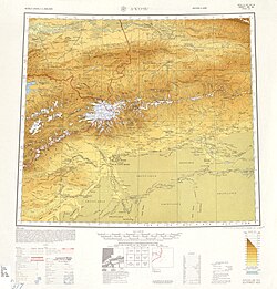 Map including the county (labeled as PAI-CH'ENG (BAI)) and surrounding region from the International Map of the World (AMS, 1950)[b]
 Map including the county (labeled as BAICHENG) (DMA, 1981)
_-_panoramio.jpg)


Notes
- Locals in Xinjiang frequently observe UTC+6 (Xinjiang Time), 2 hours behind Beijing.
- From map: "THE DELINEATION OF INTERNATIONAL BOUNDARIES ON THIS MAP MUST NOT BE CONSIDERED AUTHORITATIVE"
- From map: "The representation of international boundaries is not necessarily authoritative."
References
External links
Wikiwand - on
Seamless Wikipedia browsing. On steroids.
Remove ads