Angitis
River in Greece From Wikipedia, the free encyclopedia
The Angitis (Greek: Αγγίτης), also known as Angista (Bulgarian: Драматица; Dramatitsa), is a river in Northern Greece. It is 75 km (47 mi) long. It is an important tributary of the Strymonas.[1]
| Angitis | |
|---|---|
 The old bridge of Angitis River in Angista Rail Station (village in Nea Zichni Municipality) | |
 | |
| Native name | Αγγίτης (Greek) |
| Location | |
| Country | Greece |
| Physical characteristics | |
| Mouth | |
• location | Strymonas |
• coordinates | 40.9021°N 23.8105°E |
| Basin features | |
| Progression | Struma→ Aegean Sea |
Its source is in the Falakro mountains, in the regional unit of Drama, near the town of Prosotsani. It flows south until Fotolivos, where it turns west and enters the Serres regional unit. It flows into the Strymonas near Tragilos.
The river is the setting for a number of extreme sports, including rafting.[2] The Angitis cave is 21 km (13 mi) long. A short distance from the cave is the gorge of the Angitis, 15 km (9.3 mi) in length with a depth that reaches 100 m (330 ft) down to the river bed.
 Angitis source inside the cave
 Angitis cave
 Angitis source in front of the cave
 Angitis near the source
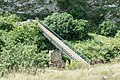 Bridge over the Angitis Canyon near the Alistratis Cave
 Bahnstation Kryopigi (Spileo Alistratis / Angitis Canyon) near the Alistratis Cave


Notes
Wikiwand - on
Seamless Wikipedia browsing. On steroids.