Ain Aata
Village in Beqaa Governorate, Lebanon From Wikipedia, the free encyclopedia
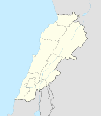
Ain Aata, Ain Ata, 'Ain 'Ata or Ayn Aata is a village and municipality situated southwest of Rashaya, 99 kilometres (62 mi) south-east of Beirut, in the Rashaya District of the Beqaa Governorate in Lebanon.[2]
Ain Aata
Ain Ata, 'Ain 'Ata, Ayn Aata | |
|---|---|
Village | |
 | |
| Country | Lebanon |
| Governorate | Beqaa Governorate |
| District | Rashaya District |
| Area | |
• Total | 22.40 sq mi (58.02 km2) |
| Elevation | 4,360 ft (1,330 m) |
| Population | |
• Total | around 4,000 |
 Cedars, in the hills of Ain Aata (2 June 1860)[1] | |
| Alternative name | Ain Aata, 'Ain 'Ata, Ayn Aata |
|---|---|
| Location | 99 kilometres (62 mi) east of Beirut |
| Region | Rashaya |
| Coordinates | 33.436390°N 35.779446°E |
| History | |
| Cultures | Roman |
| Site notes | |
| Public access | Yes |
The name is thought to mean 'gift spring'.[3] There is a remarkably cold spring in the area.[1]
History
In 1838, Eli Smith noted 'Ain 'Ata's population as being Druze and "Greek" Christians.[4] By 2014, Druze residents made up 88.52% of the 1,795 registered voters, with almost all the remainder being Greek Orthodox Christians.[5]
Roman temple
Recent epigraphic surveys have confirmed the ruins of a Roman temple and cult site in the village that are included in the group of Temples of Mount Hermon.[6][7][8][9]
See also
References
Bibliography
External links
Wikiwand - on
Seamless Wikipedia browsing. On steroids.

