Aginskoye, Zabaykalsky Krai
Urban-type settlement in Zabaykalsky Krai, Russia From Wikipedia, the free encyclopedia
Aginskoye (Russian: Аги́нское; Buryat: Ага, Aga; Mongolian: Аг, Ag) is an urban locality (an urban-type settlement) and the administrative center of Agin-Buryat Okrug and of Aginsky District in Zabaykalsky Krai, Russia. It is located in the valley of the Aga River (the Amur basin). Population: 15,596 (2010 Census);[3] 11,717 (2002 Census);[8] 9,286 (1989 Soviet census);[9] 7,200 (1967).
Aginskoye
Агинское | |
|---|---|
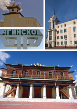
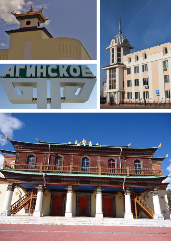
 Clockwise: Aginskoye Town Administration building, Agin-Buryat Okrug Administration building, Aginsky Datsan, Town entrance sign | |
| Coordinates: 51°06′N 114°30′E | |
| Country | Russia |
| Federal subject | Zabaykalsky Krai[1] |
| Administrative district | Aginsky District[1] |
| Founded | 1781 or 1811(see text) |
| Urban-type settlement status since | 1959[2] |
| Elevation | 675 m (2,215 ft) |
| Population | |
• Total | 15,596 |
| 17,841 (+14.4%) | |
| • Capital of | Aginsky District[1] |
| • Urban okrug | Aginskoye Urban Okrug[5] |
| • Capital of | Aginskoye Urban Okrug[5] |
| Time zone | UTC+9 (MSK+6 [6]) |
| Postal code(s)[7] | 687000, 687599 |
| OKTMO ID | 76702000051 |
| Website | go-aginskoe |

History
It was founded in 1781[1] or, according to other sources, in 1811.[2]
Administrative and municipal status
Within the framework of administrative divisions, Aginskoye serves as the administrative center of Aginsky District and is subordinated to it.[1] As a municipal division, the urban-type settlement of Aginskoye together with one rural locality in Aginsky District is incorporated as Aginskoye Urban Okrug.[10]
Climate
Summarize
Perspective
Aginskoye experiences a dry-winter borderline humid continental climate/subarctic climate (Köppen climate classification: Dwb/Dwc) with very cold, very dry winters and warm, wet summers.
| Climate data for Aginskoye (extremes 1936–present) | |||||||||||||
|---|---|---|---|---|---|---|---|---|---|---|---|---|---|
| Month | Jan | Feb | Mar | Apr | May | Jun | Jul | Aug | Sep | Oct | Nov | Dec | Year |
| Record high °C (°F) | 0.5 (32.9) |
9.2 (48.6) |
22.0 (71.6) |
30.4 (86.7) |
35.6 (96.1) |
39.7 (103.5) |
38.8 (101.8) |
37.7 (99.9) |
33.9 (93.0) |
25.8 (78.4) |
12.2 (54.0) |
5.6 (42.1) |
39.7 (103.5) |
| Mean daily maximum °C (°F) | −14.5 (5.9) |
−8.7 (16.3) |
0.0 (32.0) |
10.0 (50.0) |
18.5 (65.3) |
24.6 (76.3) |
26.5 (79.7) |
23.8 (74.8) |
17.3 (63.1) |
7.5 (45.5) |
−4.8 (23.4) |
−13.1 (8.4) |
7.3 (45.1) |
| Daily mean °C (°F) | −22.4 (−8.3) |
−17.8 (0.0) |
−8.6 (16.5) |
2.0 (35.6) |
10.1 (50.2) |
16.6 (61.9) |
19.2 (66.6) |
16.5 (61.7) |
9.2 (48.6) |
−0.2 (31.6) |
−12.1 (10.2) |
−20.2 (−4.4) |
−0.6 (30.9) |
| Mean daily minimum °C (°F) | −28.6 (−19.5) |
−25.3 (−13.5) |
−16.7 (1.9) |
−5.9 (21.4) |
1.4 (34.5) |
8.2 (46.8) |
12.1 (53.8) |
9.8 (49.6) |
2.0 (35.6) |
−6.7 (19.9) |
−18.2 (−0.8) |
−26.1 (−15.0) |
−7.8 (17.9) |
| Record low °C (°F) | −45.5 (−49.9) |
−47.6 (−53.7) |
−38.9 (−38.0) |
−25.4 (−13.7) |
−12.1 (10.2) |
−4.6 (23.7) |
0.3 (32.5) |
−4.0 (24.8) |
−12.0 (10.4) |
−32.7 (−26.9) |
−38.3 (−36.9) |
−42.4 (−44.3) |
−47.6 (−53.7) |
| Average precipitation mm (inches) | 3 (0.1) |
3 (0.1) |
5 (0.2) |
10 (0.4) |
27 (1.1) |
59 (2.3) |
95 (3.7) |
75 (3.0) |
39 (1.5) |
10 (0.4) |
6 (0.2) |
5 (0.2) |
337 (13.2) |
| Source: Pogoda.ru.net[11] | |||||||||||||
References
Wikiwand - on
Seamless Wikipedia browsing. On steroids.


