Top Qs
Timeline
Chat
Perspective
Circles of latitude between the 35th parallel north and the 40th parallel north
Circles of latitude From Wikipedia, the free encyclopedia
Remove ads
Following are circles of latitude between the 35th parallel north and the 40th parallel north:
36th parallel north
Summarize
Perspective
.svg)
36°
36th parallel north (interactive map)
The 36th parallel north is a circle of latitude that is 36 degrees north of the Earth's equatorial plane. It crosses Africa, the Mediterranean Sea, Asia, the Pacific Ocean, North America and the Atlantic Ocean. In the ancient Mediterranean world, its role for navigation and geography was similar to that played by the Equator today.[1]
From 7 April 1991 to 31 December 1996, the parallel defined the limit of the northern no-fly zone in Iraq.[2]
At this latitude the sun is visible for 14 hours, 36 minutes during the summer solstice and 9 hours, 43 minutes during the winter solstice.[3]
United States
In the United States, the 36th parallel north is occasionally used as a rough northern boundary for the Sun Belt, a region spanning most Southern and Southwestern states and comprising most of the nation's warmest climates.
Cities and landmarks close to the parallel include the following: Kettleman City, California; Henderson, Nevada; Hoover Dam; South Rim of the Grand Canyon; Los Alamos National Laboratory; Tulsa, Oklahoma (passing through the southern portion of the city); Nashville, Tennessee (passing through the southern portion of the city); Knoxville, Tennessee; Winston-Salem, North Carolina; High Point, North Carolina; Greensboro, North Carolina; Durham, North Carolina; Chapel Hill, North Carolina; and others. The parallel helped define the North Carolina–Tennessee–Virginia Corners.
The sixth standard parallel south of Mount Diablo Range at 35°48′ north, 13.8344 miles south of the 36th parallel, forms a continuous boundary between the California counties of Monterey, Kings, Tulare, and Inyo on the north and the counties of San Luis Obispo, Kern, and San Bernardino on the south.[4] It is sometimes taken as the boundary between Central California and Southern California.[5]
The parallel 36° north approximately forms the southernmost boundary of the Missouri Bootheel with the State of Arkansas.
The 36th parallel passes through Duke University in several places. Its Campus Drive that connects the campuses crosses the parallel several times.[citation needed] The Duke Gardens has a "36th Parallel Club" although the garden itself is just north of the parallel.[citation needed]
Around the world
Starting at the Prime Meridian and heading eastwards, the parallel 36° north passes through:
Remove ads
37th parallel north
Summarize
Perspective
37°
37th parallel north (interactive map)
The 37th parallel north is a circle of latitude that is 37 degrees north of the Earth's equatorial plane. It crosses Europe, the Mediterranean Sea, Africa, Asia, the Pacific Ocean, North America, and the Atlantic Ocean.
At this latitude, the Sun is visible for 14 hours, 42 minutes during the summer solstice and 9 hours, 37 minutes during the winter solstice.[6]
The 37th parallel north is roughly the northern limit of the visibility of Canopus, the second-brightest star of the night sky. Along with the 37th parallel south, it is the latitude at which solar irradiance is closest to the planetary average,[7] with higher solar irradiance equatorward and lower poleward.
United States


In the United States, the parallel defines the southern borders of Utah, Colorado, and Kansas, and the northern borders of Arizona, New Mexico, and Oklahoma. It dates to the Kansas–Nebraska Act of 1854 when Congress divided Unorganized Territory into Kansas and Nebraska north of the 37th parallel and a remainder Indian Territory to the south. Before that, the line had been thought to be the boundary between the Cherokee and Osage reservations – the 2.46 miles (3.96 km) discrepancy resulting in the creation of the Cherokee Strip. Congress extended the line west to New Mexico Territory, thus defining which states and territories would constitute The South between the Colorado and Mississippi Rivers, and creating what later became the Oklahoma Panhandle.[8]
The parallel 37° north formed the southern boundary of the historic and extralegal Territory of Jefferson.
U.S. Landmarks located on or in close proximity of the 37th parallel
- Santa Cruz, California – Located on the exact entry point into the U.S. at Bonny Doon Beach.
- Yosemite National Park — Situated in close proximity, just north of the 37th parallel.
- Death Valley – The 37th parallel runs approximately 1,300 ft south of the Little Hebe Crater rim and approximately 1,900 ft south of the larger Ubehebe Crater rim, a crater that's 800 meters (2,600 ft) wide and 235 meters (771 ft) deep.
- Area 51, Nevada — Also known as "Groom Lake".
- Four Corners, the only point where four U.S. states meet.
- Cairo, Illinois – The southernmost city in Illinois.
- Bowling Green, Kentucky
- Chesapeake Bay Bridge–Tunnel – A critical maritime and transportation structure.
Around the world
Starting at the Prime Meridian and heading eastward, the parallel 37° north passes through:
Remove ads
38th parallel north
Summarize
Perspective
38°
38th parallel north (interactive map)
The 38th parallel north is a circle of latitude that is 38 degrees north of the Earth's equatorial plane. It crosses Europe, the Mediterranean Sea, Asia, the Pacific Ocean, North America, and the Atlantic Ocean. The 38th parallel north formed the border between North and South Korea prior to the Korean War.
At this latitude, the Sun is visible for 14 hours, 48 minutes during the summer solstice and 9 hours, 32 minutes during the winter solstice.[9]
Korea

Japan had ruled the Korean Peninsula between 1910 and 1945. When Japan surrendered in August 1945, the 38th parallel was established as the boundary between Soviet and American occupation zones. This parallel divided the Korean peninsula roughly in the middle. In 1948, this parallel became the boundary between the Democratic People's Republic of Korea (North Korea) and the Republic of Korea (South Korea), both of which claim to be the government of the whole of Korea. On 25 June 1950, after a series of cross-border raids and gunfire from both the Northern and the Southern sides, the North Korean Army crossed the 38th parallel and invaded South Korea. This sparked United Nations Security Council Resolution 82 which called for the North to return its troops to behind the 38th parallel, commencing the Korean War with United Nations troops (mostly American) helping South Korean troops to defend South Korea.[10]
After the Armistice agreement was signed on July 27, 1953, a new line was established to separate North Korea and South Korea. This Military Demarcation Line is surrounded by a Demilitarized Zone. The demarcation line crosses the 38th parallel, from the southwest to the northeast.
Around the world
Starting at the Prime Meridian heading eastward, the 38th parallel north passes through:
Remove ads
39th parallel north
Summarize
Perspective
39°
39th parallel north (interactive map)
The 39th parallel north is a circle of latitude that is 39 degrees north of the Earth's equatorial plane. It crosses Europe, the Mediterranean Sea, Asia, the Pacific Ocean, North America, and the Atlantic Ocean.
At this latitude the sun is visible for 14 hours, 54 minutes during the summer solstice and 9 hours, 26 minutes during the winter solstice.[11]
Daylight along the 39th parallel north falls under 10 hours a day starting on 18 November and returns to over ten hours a day beginning 24 January. The growth of crops and other plants is considerably slowed during this period of reduced sunlight.[citation needed]
In the United States, the eastern boundary of the state of California was defined as following the 120th meridian west south from the 42nd parallel north to its intersection with the 39th parallel north, beyond which it follows a diagonal line to where the Colorado River crosses the 35th parallel north.[12] The intersection of the 120th meridian and 39th parallel is in Lake Tahoe.
Around the world
Starting at the Prime Meridian and heading eastwards, the parallel 39° north passes through:
Remove ads
40th parallel north
Summarize
Perspective
40°
40th parallel north (interactive map)
The 40th parallel north is a circle of latitude that is 40 degrees north of the Earth's equatorial plane. It crosses Europe, the Mediterranean Sea, Asia, the Pacific Ocean, North America, and the Atlantic Ocean.
At this latitude the sun is visible for 15 hours, 1 minute and 28 seconds during the summer solstice and 9 hours, 20 minutes during the winter solstice.[13] On 21 June, the maximum altitude of the sun is 73.44 degrees, while it is 26.56 degrees on 21 December.[citation needed]
The maximum altitude of the Sun is > 35.00º in October and > 28.00º in November.
The 40th parallel north is the southern baseline for Canada's National Topographic System.
United States


The parallel 40° north formed the boundary between the Kansas and Nebraska territories, as per the Kansas–Nebraska Act of 1854. It remains the boundary between the modern states of Kansas and Nebraska.
The parallel 40° north formed the original northern boundary of the British Colony of Maryland. A subsequent royal grant gave the Colony of Pennsylvania land north of the 40th parallel but mistakenly assumed it would intersect the Twelve Mile Circle, which it does not. Pennsylvania's border was thus unclear and the colony pushed for a border far south of the 40th parallel. The Mason–Dixon Line was drawn between 1763 and 1767 as the compromise boundary between the overlapping claims of these two colonies.
.jpg)
The parallel 40° north passes through the cities of Philadelphia, Pennsylvania, Boulder, Colorado, and Columbus, Ohio; as well as northern suburbs of Indianapolis, Indiana and the southern suburbs of Pittsburgh, Pennsylvania. The parallel goes directly through the John Glenn Columbus International Airport, with runway 10L-28R lying immediately north of the line, runway 10R-28L lying slightly south of it, and the line going through the northernmost edges of the terminal. It also passes through the main campus of The Ohio State University; specifically, it cuts directly across the Oval greenspace, between University Hall and the William Oxley Thompson Memorial Library. Ohio Stadium, one of the largest stadiums in the world, barely misses the parallel 40° north (6 seconds or 185 metres (607 ft) above 40° north).
Baseline Road in Boulder, Colorado, traces the parallel 40° north.
Thistle, Utah, a ghost town since 1983, is slightly (30 seconds or 956 metres (0.594 mi)) below 40° north.
Japan
Gallery
 Monument of North latitude 40 degrees at Nyudouzaki in Oga, Akita
 Nyudozaki Monument
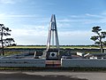 40°N and 140°E Crossing Point in Ogata, Akita
 Globe Monument in Fudai, Iwate


Around the world
Starting in Spain at the Prime Meridian and heading eastwards, the parallel 40° north passes through:
Notable cities and towns on 40°N
Remove ads
See also
- Circles of latitude between the 30th parallel north and the 35th parallel north
- Circles of latitude between the 40th parallel north and the 45th parallel north
- Baseline (surveying)
- Geological Exploration of the Fortieth Parallel
- Parallel 36°30′ north
- 38th parallel structures, series of circular depressions roughly on the 38th parallel north
- 17th parallel north, similar line dividing North and South Vietnam
Remove ads
References
Further reading
Wikiwand - on
Seamless Wikipedia browsing. On steroids.
Remove ads