Zlatenek
Place in Upper Carniola, Slovenia From Wikipedia, the free encyclopedia
Place in Upper Carniola, Slovenia From Wikipedia, the free encyclopedia
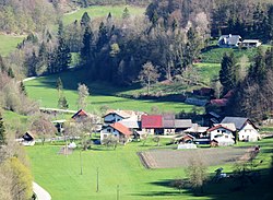
Zlatenek (pronounced [zlaˈteːnək]; in older sources also Slatenek,[2] German: Slatenk[2]) is a dispersed settlement above Blagovica in the Municipality of Lukovica in the eastern part of the Upper Carniola region of Slovenia.[3]
Zlatenek | |
|---|---|
 | |
| Coordinates: 46°10′57.25″N 14°48′8.86″E | |
| Country | |
| Traditional region | Upper Carniola |
| Statistical region | Central Slovenia |
| Municipality | Lukovica |
| Area | |
| • Total | 0.6 km2 (0.2 sq mi) |
| Elevation | 427.5 m (1,402.6 ft) |
| Population (2002) | |
| • Total | 40 |
| [1] | |
Zlatenek was attested in written sources as Oberslatenikch in 1378, Slatenik in 1379, Slätenig in 1414, and Slattonig in 1451.[4]
Seamless Wikipedia browsing. On steroids.
Every time you click a link to Wikipedia, Wiktionary or Wikiquote in your browser's search results, it will show the modern Wikiwand interface.
Wikiwand extension is a five stars, simple, with minimum permission required to keep your browsing private, safe and transparent.