Top Qs
Timeline
Chat
Perspective
Xinhe County, Xinjiang
County in Xinjiang, China From Wikipedia, the free encyclopedia

Remove ads
Xinhe County (Chinese: 新和县) as the official romanized name, also formerly known as its Uyghur name Toksu County[7] (Uyghur: توقسۇ ناھىيىسى;[8] Chinese: 托克苏县), is a county in Aksu Prefecture, Xinjiang Uyghur Autonomous Region, China.
.png)


Remove ads
Remove ads
Name
The county's original name Toksu was changed into Xinhe in 1941. "Xinhe" is the abbreviation of "Xinjiang Heping" (新疆和平), literally "Xinjiang Peace."[3][9]
History
On October 27, 1930, Toksu County was created from part of Kuqa.[3][9]
In 1941[9] or 1944,[3] Toksu County's Chinese character name was changed from 'Tuokesu' County (托克蘇縣) to 'Xinhe' County (新和縣).
Administrative divisions
Xinhe County administered 4 towns, 4 townships and 4 other areas:[10][2][11]
Climate
Remove ads
Economy
The economy is based on agriculture and also animal husbandry. The county produces wheat, corn, rice, cotton and melons as well as Parthian fennel and thin-shelled walnuts. Industries include wool-spinning, knitting, and carpet making.[3]
Demographics
As of 2015, 184,399 of the 195,920 residents of the county were Uyghur, 10,901 were Han Chinese and 620 were from other ethnic groups.[5]
According to the 2002 census, it has a population of 140,000.[citation needed]
As of 1999, 95.01% of the population of the county were Uyghur and 4.81% of the population was Han Chinese.[16]
Remove ads
Transportation
Xinhe is served by the Southern Xinjiang Railway.
Historical maps
Historical English-language maps including Toksu/Xinhe:
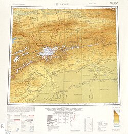 Map including Hsin-ho (Torpak Bazar) and surrounding region from the International Map of the World (AMS, 1950)[b]
 Map including Xinhe (DMA, 1981)
_-_panoramio.jpg)


Notes
- Locals in Xinjiang frequently observe UTC+6 (Xinjiang Time), 2 hours behind Beijing.
References
Wikiwand - on
Seamless Wikipedia browsing. On steroids.
Remove ads