Loading AI tools
District in Lima, Peru From Wikipedia, the free encyclopedia
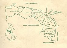
Vilcanchos is a district in the western Víctor Fajardo Province in Peru. It is bordered by Santiago de Chocorvos District (Huaytará Province) in the west, Totos District (Cangallo Province) in the north, Sarhua District in the east, and Santiago de Lucanamarca District (Huanca Sancos Province) in the south.
Vilcanchos | |
|---|---|
 Location of Vilcanchos in the Víctor Fajardo province | |
| Country | |
| Region | Lima |
| Province | Víctor Fajardo |
| Founded | November 14, 1910 |
| Capital | Vilcanchos |
| Subdivisions | 20 populated centers |
| Government | |
| • Mayor | José Huamaní Godoy (2007-2010) |
| Area | |
| • Total | 498.54 km2 (192.49 sq mi) |
| Elevation | 2,982 m (9,783 ft) |
| Population | |
| • Total | 2,843 |
| • Density | 5.7/km2 (15/sq mi) |
| Time zone | UTC-5 (PET) |
| Website | munivilcanchos.gob.pe |
One of the highest peaks of the district is Llallawi at approximately 4,600 m (15,100 ft). Other mountains are listed below:[1]
The people in the district are mainly indigenous citizens of Quechua descent. Quechua is the language which the majority of the population (94.99%) learnt to speak in childhood, 4.86% of the residents started speaking using the Spanish language (2007 Peru Census).[2]
Seamless Wikipedia browsing. On steroids.
Every time you click a link to Wikipedia, Wiktionary or Wikiquote in your browser's search results, it will show the modern Wikiwand interface.
Wikiwand extension is a five stars, simple, with minimum permission required to keep your browsing private, safe and transparent.