Loading AI tools
District in Suphan Buri, Thailand From Wikipedia, the free encyclopedia
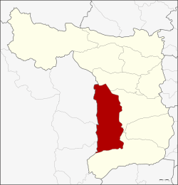
U Thong (Thai: อู่ทอง, pronounced [ʔùː tʰɔ̄ːŋ]) is the district (amphoe) in the western part of Suphan Buri province, north of Bangkok.[1]
U Thong
อู่ทอง | |
|---|---|
 District location in Suphan Buri province | |
| Coordinates: 14°22′32″N 99°53′32″E | |
| Country | Thailand |
| Province | Suphan Buri |
| Area | |
| • Total | 630.29 km2 (243.36 sq mi) |
| Population (2013) | |
| • Total | 121,421 |
| Time zone | UTC+7 (ICT) |
| Postal code | 72160 |
| Geocode | 7209 |


Higham states, "U-Thong was occupied for many centuries prior to the development of the Dvaravati state. Radiocarbon determinations from the sites of U-Thong and Chansen suggest that the transition into complex state societies in the Chao Phraya basin took place between about 300-600 AD." A copper inscription from the mid-7th century states, "Sri Harshavarman, grandson of Ishanavarman, having expanded his sphere of glory, obtained the lion throne through regular succession," and mentions gifts to a linga. The site includes a moat, 1,690 by 840 m, and the Pra Paton caitya.[2]: 300, 302, 306–307
It also became the origin of the Ayutthaya Kingdom, as the first King of Ayutthaya, Ramathibodi, was prince of U Thong when the city was struck by an epidemic, prompting him to relocate east and found Ayutthaya.[3]
U Thong district was created with the name Chorakhe Sam Phan in 1905. In 1939 the district was renamed U Thong.[4] In 1944, the government moved the centre of the district from Ban Chorakhe Sam Phan to the area of the ancient city.[5]
Neighbouring districts are (from the north clockwise): Don Chedi, Mueang Suphan Buri, Bang Pla Ma, Song Phi Nong of Suphan Buri Province; Lao Khwan, Huai Krachao, and Phanom Thuan of Kanchanaburi province.

U Thong district is divided into 13 sub-districts (tambons), which are further subdivided into 154 administrative villages (mubans).
| No. | Name | Thai | Villages | Pop.[6] |
|---|---|---|---|---|
| 1. | U Thong | อู่ทอง | 11 | 23,868 |
| 2. | Sa Yai Som | สระยายโสม | 10 | 8,352 |
| 3. | Chorakhe Sam Phan | จรเข้สามพัน | 15 | 13,105 |
| 4. | Ban Don | บ้านดอน | 9 | 7,710 |
| 5. | Yung Thalai | ยุ้งทะลาย | 7 | 4,497 |
| 6. | Don Makluea | ดอนมะเกลือ | 12 | 4,548 |
| 7. | Nong Ong | หนองโอ่ง | 14 | 9,859 |
| 8. | Don Kha | ดอนคา | 20 | 13,245 |
| 9. | Phlapphla Chai | พลับพลาไชย | 14 | 11,854 |
| 10. | Ban Khong | บ้านโข้ง | 14 | 8,855 |
| 11. | Chedi | เจดีย์ | 8 | 3,076 |
| 12. | Sa Phang Lan | สระพังลาน | 10 | 5,203 |
| 13. | Krachan | กระจัน | 10 | 7,249 |
There are nine sub-district municipalities (thesaban tambons) in the district:
There are six sub-district administrative organizations (SAO) in the district:
Seamless Wikipedia browsing. On steroids.
Every time you click a link to Wikipedia, Wiktionary or Wikiquote in your browser's search results, it will show the modern Wikiwand interface.
Wikiwand extension is a five stars, simple, with minimum permission required to keep your browsing private, safe and transparent.