Tonto Creek
Stream in Gila County, Arizona From Wikipedia, the free encyclopedia
Stream in Gila County, Arizona From Wikipedia, the free encyclopedia
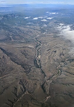
Tonto Creek is a 72.5-mile-long (116.7 km)[3] stream located in the Mogollon Rim area of the state of Arizona on the north edge of the Tonto National Forest. The closest town, Payson, is 18 miles (29 km) away. Tonto Creek is a stream that flows year round, starting just below the Mogollon Rim, at the northern edge of Tonto National Forest. The creek continues its descent through the Hellsgate Wilderness area and eventually into a wide valley in the Sonoran Desert. It continues through the desert and into the Salt River within the north end of Theodore Roosevelt Lake.[4] The facilities are maintained by Tonto National Forest division of the USDA Forest Service.
| Tonto Creek | |
|---|---|
 Tonto Creek (right and foreground) with tributary Rye Creek (center background) | |
 | |
| Location | |
| Country | United States |
| State | Arizona |
| County | Gila and Coconino |
| Physical characteristics | |
| Source | |
| • coordinates | 34°23′37″N 111°04′52″W[1] |
| • elevation | 7,640 feet (2,330 m)[2] |
| Mouth | |
• location | Theodore Roosevelt Lake |
• coordinates | 33°40′48″N 111°09′05″W[1] |
• elevation | 2,096 feet (639 m)[1] |
| Length | 72.5 miles (116.7 km) |

Fish in the stream include rainbow trout, brown trout, and brook trout.[5]
Seamless Wikipedia browsing. On steroids.
Every time you click a link to Wikipedia, Wiktionary or Wikiquote in your browser's search results, it will show the modern Wikiwand interface.
Wikiwand extension is a five stars, simple, with minimum permission required to keep your browsing private, safe and transparent.