Tinjan
Municipality in Istria County, Croatia From Wikipedia, the free encyclopedia
Municipality in Istria County, Croatia From Wikipedia, the free encyclopedia
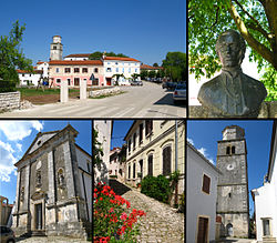
Tinjan (Italian: Antignana) is a village and municipality in Istria, Croatia.
Tinjan
Antignana | |
|---|---|
Municipality | |
 | |
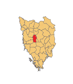
 Location of Tinjan in Istria | |
| Coordinates: 45°13′02″N 13°50′20″E | |
| Country | |
| County | |
| Area | |
| • Municipality | 20.4 sq mi (52.8 km2) |
| • Urban | 4.2 sq mi (10.8 km2) |
| Population (2021)[2] | |
| • Municipality | 1,729 |
| • Density | 85/sq mi (33/km2) |
| • Urban | 433 |
| • Urban density | 100/sq mi (40/km2) |
| Time zone | UTC+1 (CET) |
| • Summer (DST) | UTC+2 (CEST) |
| Postal code | 52465 Tar |
| Area code | 052 |
| Website | tinjan |
Tinjan is located is 50 km north of Pula and 10 km southwest of Pazin, in the Draga valley. The Coat of Arms of Tinjan is azure on a base vert a tower argent behind walls of the same. This is based on the historical pattern.
According to the 2021 census, its population was 1,729 with 433 living in the village proper.[2] The total population was 1,684 in 2011, distributed in the following settlements:[3]
Seamless Wikipedia browsing. On steroids.
Every time you click a link to Wikipedia, Wiktionary or Wikiquote in your browser's search results, it will show the modern Wikiwand interface.
Wikiwand extension is a five stars, simple, with minimum permission required to keep your browsing private, safe and transparent.