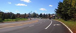
Ten Mile Run, New Jersey
Populated place in Somerset County, New Jersey, US From Wikipedia, the free encyclopedia
Populated place in Somerset County, New Jersey, US From Wikipedia, the free encyclopedia
Ten Mile Run is an unincorporated community and census-designated place (CDP) located in Franklin Township, in Somerset County, in the U.S. state of New Jersey.[2][7][8][9] As of the 2010 United States Census, the CDP's population was 1,959.[10]
Ten Mile Run, New Jersey | |
|---|---|
 | |
Location in Somerset County Location in New Jersey | |
| Coordinates: 40.424136°N 74.586348°W[1][2] | |
| Country | |
| State | |
| County | Somerset |
| Township | Franklin |
| Area | |
| • Total | 2.54 sq mi (6.58 km2) |
| • Land | 2.54 sq mi (6.58 km2) |
| • Water | 0.00 sq mi (0.00 km2) 0.04% |
| Elevation | 213 ft (65 m) |
| Population | |
| • Total | 2,055 |
| • Density | 809.37/sq mi (312.50/km2) |
| Time zone | UTC−05:00 (Eastern (EST)) |
| • Summer (DST) | UTC−04:00 (Eastern (EDT)) |
| Area code(s) | 609/640 and 732/848 |
| FIPS code | 34-72435[1][2][6] |
| GNIS feature ID | 02584033[1][2] |
According to the United States Census Bureau, Ten Mile Run had a total area of 2.539 square miles (6.576 km2), including 2.538 square miles (6.573 km2) of land and 0.001 square miles (0.002 km2) of water (0.04%).[1][2]
The area is named for the Ten Mile Run, a stream of the same name the hill on which it sits (part of the Rocky Hill Ridge).[11] The area is located along Route 27 (Lincoln Highway) near its intersection with County Route 518. It is located across Route 27 from South Brunswick, Middlesex County. Most of the area consists of less densely-spaced single family homes throughout and commercial establishments along Route 27. The remainder of the area is forested and hilly as the terrain descends towards the Delaware and Raritan Canal and Millstone River. Kendall Park, the CDP located on the South Brunswick side of Route 27, consists of more densely-spaced homes.[12]
The 2010 United States census counted 1,959 people, 602 households, and 514 families in the CDP. The population density was 771.9 per square mile (298.0/km2). There were 622 housing units at an average density of 245.1 per square mile (94.6/km2). The racial makeup was 31.85% (624) White, 11.94% (234) Black or African American, 0.05% (1) Native American, 50.54% (990) Asian, 0.00% (0) Pacific Islander, 2.30% (45) from other races, and 3.32% (65) from two or more races. Hispanic or Latino of any race were 6.33% (124) of the population.[10]
Of the 602 households, 49.8% had children under the age of 18; 79.6% were married couples living together; 3.8% had a female householder with no husband present and 14.6% were non-families. Of all households, 10.1% were made up of individuals and 3.2% had someone living alone who was 65 years of age or older. The average household size was 3.25 and the average family size was 3.53.[10]
29.4% of the population were under the age of 18, 3.5% from 18 to 24, 33.9% from 25 to 44, 24.9% from 45 to 64, and 8.3% who were 65 years of age or older. The median age was 37.0 years. For every 100 females, the population had 105.3 males. For every 100 females ages 18 and older there were 103.2 males.[10]
Seamless Wikipedia browsing. On steroids.
Every time you click a link to Wikipedia, Wiktionary or Wikiquote in your browser's search results, it will show the modern Wikiwand interface.
Wikiwand extension is a five stars, simple, with minimum permission required to keep your browsing private, safe and transparent.