Loading AI tools
District in Prachinburi, Thailand From Wikipedia, the free encyclopedia
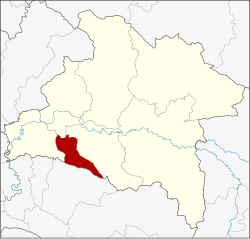
Si Mahosot (Thai: ศรีมโหสถ, pronounced [sǐː mā.hǒː.sòt]) is a district (amphoe) of Prachinburi province, eastern Thailand. It may also be spelled Sri Mahosot.
Si Mahosot
ศรีมโหสถ | |
|---|---|
 District location in Prachinburi province | |
| Coordinates: 13°52′54″N 101°24′24″E | |
| Country | Thailand |
| Province | Prachinburi |
| Seat | Khok Pip |
| Area | |
| • Total | 130.830 km2 (50.514 sq mi) |
| Population (2005) | |
| • Total | 18,137 |
| • Density | 138.6/km2 (359/sq mi) |
| Time zone | UTC+7 (ICT) |
| Postal code | 25190 |
| Geocode | 2509 |
Neighboring districts are (from the west clockwise): Ban Sang, Mueang Prachinburi and Si Maha Phot of Prachinburi Province; and Phanom Sarakham of Chachoengsao province.
The minor district (king amphoe) Khok Pip was established on 15 February 1970, when the three tambons, Khok Pip, Khu Lam Phan, and Phai Cha Lueat were split off from Si Maha Phot district.[1] It was upgraded to a full district on 13 April 1977,[2] and renamed Si Mahosot on 3 June 1993.[3]
The district is divided into four sub-districts (tambons), which are further subdivided into 24 villages (mubans). Khok Pip is a township (thesaban tambon) which covers parts of tambon Khok Pip. There are a further three tambon administrative organizations (TAO).
| No. | Name | Thai name | Villages | Pop. | |
|---|---|---|---|---|---|
| 1. | Khok Pip | โคกปีบ | 9 | 9,090 | |
| 2. | Khok Thai | โคกไทย | 7 | 6,000 | |
| 3. | Khu Lam Phan | คู้ลำพัน | 4 | 1,193 | |
| 4. | Phai Cha Lueat | ไผ่ชะเลือด | 4 | 1,854 |
Seamless Wikipedia browsing. On steroids.
Every time you click a link to Wikipedia, Wiktionary or Wikiquote in your browser's search results, it will show the modern Wikiwand interface.
Wikiwand extension is a five stars, simple, with minimum permission required to keep your browsing private, safe and transparent.