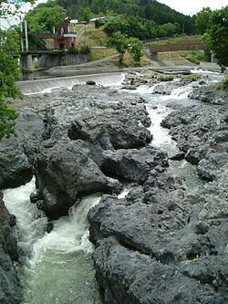
Shokotsu River
River in Hokkaidō, Japan From Wikipedia, the free encyclopedia
River in Hokkaidō, Japan From Wikipedia, the free encyclopedia
Shokotsu River (渚滑川, Shokotsu-gawa) is a river in Hokkaidō, Japan. It is designated a Class A river by the Ministry of Land, Infrastructure, Transport and Tourism.
| Shokutsu River 渚滑川 | |
|---|---|
 | |
 | |
| Native name | Shokotsu-gawa (Japanese) |
| Location | |
| Country | Japan |
| State | Hokkaidō |
| Region | Abashiri |
| District | Monbetsu |
| Municipalities | Monbetsu, Takinoue |
| Physical characteristics | |
| Source | Mount Teshio |
| • location | Takinoue, Hokkaidō, Japan |
| • coordinates | 43°57′52″N 142°53′17″E |
| • elevation | 1,557.6 m (5,110 ft) |
| Mouth | Sea of Okhotsk |
• location | Monbetsu, Hokkaidō, Japan |
• coordinates | 44°22′48″N 143°19′22″E |
• elevation | 0 m (0 ft) |
| Length | 84 km (52 mi) |
| Basin size | 1,240 km2 (480 sq mi) |
| Discharge | |
| • average | 33.22 m3/s (1,173 cu ft/s) |
The river rises on the slopes of Mount Teshio in the Kitami Mountains. After flowing through Takinoue, the river is joined by the Sakurū and Tatsuushi Rivers. At Kamishokotsu in Monbetsu, the river leaves the mountains for the coastal plain. There it is joined by the Utsutsu River before flowing into the Sea of Okhotsk at Shokotsu in Monbetsu.[1]
From river mouth to source:
From river mouth to source:
Seamless Wikipedia browsing. On steroids.
Every time you click a link to Wikipedia, Wiktionary or Wikiquote in your browser's search results, it will show the modern Wikiwand interface.
Wikiwand extension is a five stars, simple, with minimum permission required to keep your browsing private, safe and transparent.