Loading AI tools
From Wikipedia, the free encyclopedia
Sheep Island is a small uninhabited island situated off the southern tip of the Kintyre peninsula in Scotland.
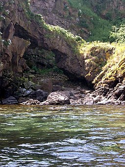
 A natural arch on Sheep Island | |
| Location | |
|---|---|
| OS grid reference | NR7328305574 |
| Coordinates | 55.29128°N 5.57209°W |
| Administration | |
| Council area | Argyll and Bute |
| Country | Scotland |
| Sovereign state | United Kingdom |
| Demographics | |
| Population | 0 |
Sheep Island, along with Sanda Island and Glunimore Island, form a small group of islands approximately three kilometres (two miles) south of Kintyre at grid reference NR733055.
Running roughly north to south, the island is around 600 metres (650 yards) long, and is steep and precipitous along the west coast, rising to a maximum height of 41 metres (135 feet). There is a cave on the west coast and a natural arch at the northwest of the island.[1] A considerable reef of drying rocks surrounds the island and makes landing on the island problematic. There are a number of strong tidal races in the area, Tum ba nach is one that extends north from Sheep Island to around halfway across the Sound of Sanda.
As the name suggests, sheep have traditionally been grazed here, however the island is more notable as the primary breeding ground for puffins in the Clyde. From here the birds are returning to nearby Ailsa Craig, where they were once wiped out. Guillemots and razorbills also nest on Sheep Island.
Seamless Wikipedia browsing. On steroids.
Every time you click a link to Wikipedia, Wiktionary or Wikiquote in your browser's search results, it will show the modern Wikiwand interface.
Wikiwand extension is a five stars, simple, with minimum permission required to keep your browsing private, safe and transparent.