Shahritus
Place in Khatlon Region, Tajikistan From Wikipedia, the free encyclopedia
Place in Khatlon Region, Tajikistan From Wikipedia, the free encyclopedia
Shahritus (before 2021 Shahrituz[2] Tajik: Шаҳритуз. , now Шаҳритӯс Shahritŭs) is a town in Khatlon Region, southwestern Tajikistan. Situated on the river Kofarnihon, the city was founded in 1938. Its population is 17,200 (January 2020 estimate).[3] It is the seat of the Shahritus District.
Shahritus
Шаҳритӯс | |
|---|---|
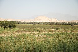
 Shahritus (Shaartuz), 4 km west cotton field | |
| Coordinates: 37°16′N 68°08′E | |
| Country | Tajikistan |
| Region | Khatlon Region |
| District | Shahritus District |
| Elevation | 367 m (1,204 ft) |
| Population (2020) | |
| • Total | 17,200 |
| Time zone | UTC+5 |
Shahritus has a cold semi-arid climate (Köppen climate classification BSk). The average annual temperature is 17.2 °C (63.0 °F). The warmest month is July with an average temperature of 30.2 °C (86.4 °F) and the coolest month is January with an average temperature of 3.3 °C (37.9 °F). The average annual precipitation is 235.7 mm (9.28 in) and has an average of 59.2 days with precipitation. The wettest month is March with an average of 58.0 mm (2.28 in) of precipitation and the driest month is August with an average of 0 mm of precipitation.[1]
| Climate data for Shahrituz | |||||||||||||
|---|---|---|---|---|---|---|---|---|---|---|---|---|---|
| Month | Jan | Feb | Mar | Apr | May | Jun | Jul | Aug | Sep | Oct | Nov | Dec | Year |
| Daily mean °C (°F) | 3.3 (37.9) |
5.8 (42.4) |
11.6 (52.9) |
18.2 (64.8) |
23.5 (74.3) |
28.6 (83.5) |
30.2 (86.4) |
28.1 (82.6) |
23.2 (73.8) |
17.0 (62.6) |
10.7 (51.3) |
5.8 (42.4) |
17.2 (63.0) |
| Average precipitation mm (inches) | 34.5 (1.36) |
37.2 (1.46) |
58.0 (2.28) |
39.0 (1.54) |
18.8 (0.74) |
0.5 (0.02) |
0.2 (0.01) |
0.0 (0.0) |
0.1 (0.00) |
5.7 (0.22) |
16.0 (0.63) |
25.7 (1.01) |
235.7 (9.28) |
| Average precipitation days (≥ 0.1 mm) | 7.9 | 8.6 | 11.1 | 9.1 | 5.9 | 0.8 | 0.4 | 0.0 | 0.1 | 2.8 | 4.8 | 7.7 | 59.2 |
| Average relative humidity (%) | 74.1 | 70.8 | 67.7 | 62.5 | 49.1 | 33.7 | 32.3 | 33.4 | 36.4 | 46.8 | 60.3 | 71.5 | 53.2 |
| Source: "The Climate of Shahrituz". Weatherbase. Retrieved 4 August 2014. | |||||||||||||
The railway crosses the river at this point.
Seamless Wikipedia browsing. On steroids.
Every time you click a link to Wikipedia, Wiktionary or Wikiquote in your browser's search results, it will show the modern Wikiwand interface.
Wikiwand extension is a five stars, simple, with minimum permission required to keep your browsing private, safe and transparent.